Toledo Weather - Wed, Feb 12, 2014
special weather statement
national weather service cleveland oh
428 am est wed feb 12 2014
ohz003-006>014-017>023-027>033-036>038-047-089-paz001>003-121330-
lucas-wood-ottawa-sandusky-erie oh-lorain-cuyahoga-lake-geauga-
ashtabula inland-hancock-seneca-huron-medina-summit-portage-
trumbull-wyandot-crawford-richland-ashland-wayne-stark-mahoning-
marion-morrow-holmes-knox-ashtabula lakeshore-northern erie-
southern erie-crawford pa-
including the cities of...toledo...bowling green...port clinton...
fremont...sandusky...lorain...cleveland...mentor...chardon...
jefferson...findlay...tiffin...norwalk...medina...akron...
ravenna...warren...upper sandusky...carey...bucyrus...mansfield...
ashland...wooster...canton...youngstown...marion...mount gilead...
millersburg...mount vernon...ashtabula...erie...edinboro...
meadville
428 am est wed feb 12 2014
temperatures will be very cold across the region early this
morning...ranging from near zero to 15 degrees below. winds will
be calm in most areas and patchy freezing fog is developing.
if freezing fog becomes dense it can cause slick spots on
untreated roads and sidewalks. persons should dress warmly today
and limit exposure to the cold.
hazardous weather outlook
national weather service cleveland oh
434 am est wed feb 12 2014
ohz003-006>014-017>023-027>033-036>038-047-089-paz001>003-130945-
lucas-wood-ottawa-sandusky-erie oh-lorain-cuyahoga-lake-geauga-
ashtabula inland-hancock-seneca-huron-medina-summit-portage-trumbull-
wyandot-crawford-richland-ashland-wayne-stark-mahoning-marion-morrow-
holmes-knox-ashtabula lakeshore-northern erie-southern erie-
crawford pa-
434 am est wed feb 12 2014
this hazardous weather outlook is for north central
ohio...northeast ohio...northwest ohio and northwest pennsylvania.
.day one...today and tonight.
temperatures will range from zero to 15 below early this morning.
persons should dress warmly and limit exposure to the cold.
.days two through seven...thursday through tuesday.
no hazardous weather is expected at this time.
.spotter information statement...
spotter activation is not expected at this time.
TOL
Feb 12, 2014 5:52 am
Weather : Overcast
Temperature : -12 F
Humidity : 81%
Wind Speed : Calm
Barometer : 30.39 in
Dewpoint: -16 F
Visibility : 2.50 statute miles
(formerly Metcalf Airport)
Feb 12, 2014 5:53 am
Weather : Mostly Cloudy
Temperature : -10 F
Humidity : 74%
Wind Speed : Calm
Barometer : 30.40 in
Dewpoint: -16 F
Visibility : 8.00 statute miles
(near Lambertville)
Feb 12, 2014 6:35 am
Weather : Fair
Temperature : -9 F
Humidity : 70%
Wind Speed : Calm
Barometer : 30.39 in
Dewpoint: -17 F
Visibility : 10.00 statute miles
Toledo 7-day forecast
Last Update: Feb 12, 2014 3:43 am
Today: Sunny, with a high near 18. Wind chill values as low as -10. Calm wind.
Tonight: Partly cloudy, with a low around 3. Calm wind.
Thursday: Mostly sunny, with a high near 27. Calm wind becoming south 5 to 8 mph in the afternoon.
Thursday Night: A slight chance of snow showers after 1am. Mostly cloudy, with a low around 19. Southwest wind 8 to 13 mph. Chance of precipitation is 20%.
Friday: A chance of snow. Cloudy, with a high near 27. West wind 11 to 16 mph, with gusts as high as 29 mph. Chance of precipitation is 40%.
Friday Night: Mostly cloudy, with a low around 8.
Saturday: Partly sunny, with a high near 19.
Saturday Night: A chance of snow showers. Mostly cloudy, with a low around 8. Chance of precipitation is 30%.
Sunday: Mostly cloudy, with a high near 24.
Sunday Night: Mostly cloudy, with a low around 13.
Washington's Birthday: Snow likely. Cloudy, with a high near 38. Chance of precipitation is 60%.
Monday Night: A chance of rain and snow. Cloudy, with a low around 32. Chance of precipitation is 50%.
Tuesday: A slight chance of rain showers. Mostly cloudy, with a high near 35.
fxus61 kcle 120914
afdcle
area forecast discussion
national weather service cleveland oh
414 am est wed feb 12 2014
synopsis...
a ridge extending from high pressure over new england will linger
over the area through thursday. a clipper will pass north of lake
erie on friday and pull a cold front across the region. high pressure
will return on saturday with another weak area of low pressure
sliding through the ohio valley on saturday night.
&&
near term /until 6 pm this evening/...
a ridge will linger over the area today...extending from high
pressure over new england. temperatures are starting off very cold
with findlay down to -15 at 330 am. winds are calm in most areas so
we do not have any type of wind chill headlines in effect. skies
have finally cleared and will remain sunny today with systems
passing both to our north and south. the airmass is very dry with
pw values near 0.08 inches. a light southeasterly wind will develop
with weak warm advection. after a cold start to the day...
temperatures will recover to the low 20s.
&&
short term /6 pm this evening through saturday night/...
tonight will be cold again with mostly clear skies and a ridge
still over the area. temperatures will approach zero in nw ohio
while lows are only forecast to drop to around 10 degrees in ne
oh/nw pa where we may hold onto just enough wind to not decouple.
also counting on a little bit of mid-level cloud. these
temperatures could potentially be too warm though if skies are
clear and winds go calm again. a good deal of sun is expected
again on thursday with temperatures reaching the upper 20s to near
30 degrees.
a clipper will move across the central great lakes from late
thursday night into friday. very dry mid-level air wraps around the
south side of the system which will limit chances for precipitation.
the gfs and canadian models hint there could be trace amounts of
precipitation around with the frontal passage late thursday
night...and the lack of ice nuclei in the cloud suggests it could
be in the form of freezing drizzle. think potential for freezing
drizzle is very low given a 6-8 degree dewpoint depression and
winds increasing to 10-15 knots. removed chances of snow from the
forecast for most areas and we will keep an eye on freezing
drizzle potential.
a shortwave will slide across illinois and southern ohio on friday
with increasing moisture and a light warm advection type snow
filling in across southern and possibly central ohio. a low level
trough also pushes south across lake erie which may help to enhance
convergence downwind of the lake bringing light snow showers. some
minor accumulations will be possible...mainly in the snowbelt.
scattered snow showers could even linger into saturday in ne oh/nw
pa as a trough lingers over the lake.
another clipper moves through the northwest flow towards the ohio
valley on friday night. this will again bring an opportunity for
light snow but models have trended southward and will just carry
30-40 pops with better chances to our south.
&&
long term /sunday through tuesday/...
high pressure will briefly ridge across the the area saturday
afternoon into sunday. as this high moves east of the area it will
allow a much stronger storm system to move into the central or
southern great lakes late monday into tuesday. southerly winds ahead
of this low will bring some warmth back to the region with highs
within a couple degrees of 40 for a large portion of the county
warning area. models differ on the exact track of this low which
will have significant implications on the precipitation type. for
now have gone with rain...snow...or a mix. this area of low pressure
should be east of the region by wednesday.
&&
aviation /06z wednesday through sunday/...
high pressure will continue to build over the area. skies are skc
and will remain that way overnight. there should be a few high
clouds on wednesday. light and variable flow will become se at
under 10 knots on wednesday. still expecting some patchy mvfr fog
inland areas later tonight.
outlook...non-vfr in clouds and or visibilities will develop
thursday evening and continue off and on through saturday night.
&&
marine...
high pressure will move away from lake erie to the new england coast
today. this will allow the next clipper storm system to move into
the region from the upper great lakes. as it passes across the
region it will drag a cold front across the area. the front should
clear all of lake erie by saturday morning. high pressure will then
briefly ridge across the lake saturday afternoon into sunday. a much
stronger storm system will move into the central or southern great
lakes late monday into tuesday. gusty winds may make a run at gale
force in the wake of it but the models are differing on the timing
of the strong area of low pressure across the region.
&&
http://wunderground.com/wundermap
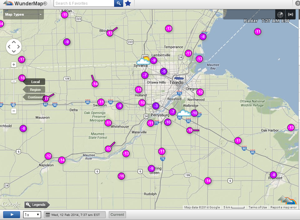
Toledo area temps at 7:37 a.m.
From JR's : articles
1358 words - 8842 chars
- 7 min read
created on
updated on
- #
source
- versions
Related articles
Severe weather threat for Sun, Nov 17, 2013 - Nov 18, 2013
Nov 17, 2013 Toledo area weather notes - Mar 03, 2014
Posts related to Nov 17, 2013 severe weather - Nov 21, 2013
Toledo area weather for early December 2013 - Dec 05, 2013
Mon, Dec 9, 2013 winter storm forecast for Sat, Dec 14 - Dec 14, 2013
more >>