Toledo Weather - Thu, Mar 6, 2014
TOL:
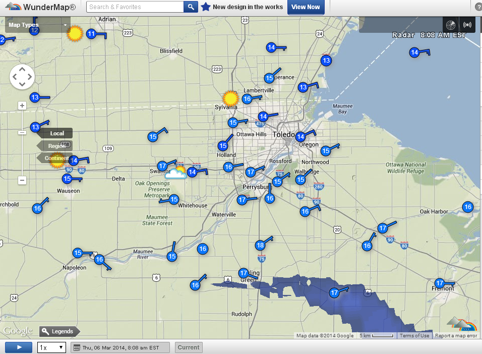
Mar 6, 2014 7:52 am
Weather : Mostly Cloudy
Temperature : 14 F
Humidity : 73%
Wind Speed : E 12 mph
Barometer : 30.41 in
Dewpoint: 7 F
Visibility : 10.00 statute miles
Wind Chill : 0 F
Toledo 7-day forecast
Last Update: Mar 6, 2014 6:50 am
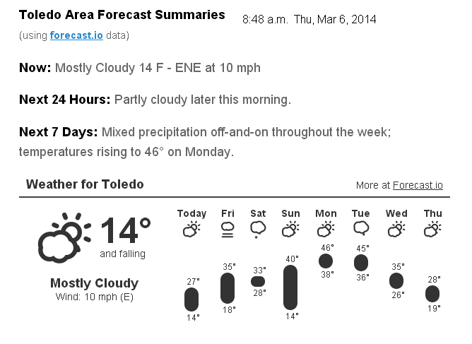
Today: Mostly sunny, with a high near 24. East wind 10 to 13 mph.
Tonight: Partly cloudy, with a low around 15. East wind 5 to 7 mph becoming calm in the evening.
Friday: Mostly sunny, with a high near 40. Calm wind becoming south around 6 mph.
Friday Night: Mostly cloudy, with a low around 28. Southwest wind 5 to 7 mph.
Saturday: A chance of snow. Cloudy, with a high near 34. Light and variable wind becoming northeast 5 to 8 mph in the afternoon. Chance of precipitation is 50%.
Saturday Night: Mostly cloudy, with a low around 17.
Sunday: Mostly sunny, with a high near 33.
Sunday Night: Partly cloudy, with a low around 27.
Monday: Partly sunny, with a high near 45.
Monday Night: Mostly cloudy, with a low around 32.
Tuesday: A chance of showers. Mostly cloudy, with a high near 42. Chance of precipitation is 30%.
Tuesday Night: A chance of snow showers. Mostly cloudy, with a low around 25. Chance of precipitation is 30%.
Wednesday: A chance of snow showers. Mostly cloudy, with a high near 35. Chance of precipitation is 30%.
fxus61 kcle 061159
afdcle
area forecast discussion
national weather service cleveland oh
659 am est thu mar 6 2014
synopsis...
arctic high pressure over eastern canada will move east and off
the east coast tonight. a south flow with warmer temperatures
will develop as the high moves east. a cold front will sag south
across the region saturday morning. high pressure will build over
the lower great lakes by sunday.
&&
near term /until 6 pm this evening/...
made a few adjustments to the hourly temps and sky cover for the
early morning update otherwise the forecast seems on track.
earlier discussion...
the large area of arctic surface high pressure over eastern canada
will slide east today. as it does so...the boundary flow will come
around from the east southeast. this will help moderate
temps...mainly across ne oh... where the flow will become down
slope as an inverted trough develops. the forecast will keep
toward the colder temperature guidance across nw ohio and extreme
nw pa (mid/upper 20s) and go with the warmer guidance for ne oh
(lower 30s). meanwhile the trof aloft over the midwest will slowly
move east. not much upward motion progged and looking upstream we
find only patches of cloud cover... mostly between 050-100. cannot
rule out a snow flake or a little virga this morning but will not
mention anything in the forecast. the clouds should thin this
afternoon as subsidence increases.
&&
short term /6 pm this evening through sunday night/...
we should actually see weather that is more seasonable the next few
days. temperatures will drop off this evening but should begin to
rise tonight as the south wind begins to pick up. sunshine and
warmer for friday. will go a few degrees above guidance friday since
we should be in a zone of subsidence between the low along the
southeast coast and the approaching cold front over the great
lakes. high clouds will begin to increase in the afternoon.
most of the models agree that the next cold front will begin to
slide south across the area early saturday morning. the models
have also been consistent in generating post frontal
precipitation. it is likely the front will be shallow at first.
some rain may occur but as it gets colder aloft we should see the
precipitation turn to snow. hopefully there will be no freezing
rain in between. highs on saturday in the 30s.
warm advection will begin quickly on sunday as a warm front
develops across the great lakes. a rain or snow shower is
possible sunday night as the next short wave begins to dive across
the great lakes.
forecast temperatures will be relatively close to guidance except a
couple of degrees colder across the far northern counties...
especially around toledo and the snowbelt where there will still be
decent snow cover.
&&
long term /monday through wednesday/...
are we in for a treat or is this just winter saying it is not
finished yet. upper level pattern made a significant change in the
extended periods. monday appears the region will be under the
influence of a nearly zonal flow across the united states and not
stuck in one of the lazy upper level troughs we have seen all winter
as a result of the sloppy polar jet stream. sure enough...the
sloppiness looks like it will return in earnest by wednesday as a
major ridge amplifies dramatically over the western united states
causing a trough to dig into the eastern united states by thursday
morning. unfortunately...this will result in another oklahoma
panhandle hook that will thankfully remain well south of the
forecast area. this feature could brush our area by weeks end. until
then...weak low pressure will race east across the northern great
lakes by monday night into tuesday. this feature will be starved for
moisture as it makes its way east but with upper level support could
ring out a few snow or rain showers as it moves by. so will keep the
mention of precipitation in for monday. stationary front sets up
over the region on tuesday and some limited moisture could stream
northeast along the boundary and keep the threat for precipitation
going through wednesday and then exit to the east on thursday. big
question during this period is where the boundary will be to make
the difference between 30s and well into the 40s for highs through
the period.
&&
aviation /12z thursday through monday/...
large area of high pressure at the surface continues to dominate
the weather across the region. however...an upper level
disturbance will move east across the area this morning and
produce some mid and high level clouds. otherwise...clearing will
take place tonight. winds will be fairly light around 8 to 10
knots at all taf sites except erie. expecting 10 to 15 knot winds
there today. generally variable winds all areas tonight.
outlook...non vfr possible late friday night into early sunday...then
again monday.
&&
marine...
high pressure will gradually shift off to the east through friday
afternoon setting up a southerly component to the wind. then...weak
low pressure moves by to the north forcing a weak cold front across
the area followed by more high pressure. the secondary high will
build south across the central united states by sunday and extend a
ridge northeast over the lake. the high will then become resident
over florida by monday while weak low pressure quickly moves
southeast into the great lakes region. pressure gradient across the
lake will rise and fall through the period. winds will gradually
weaken with time by friday night and remain generally light through
sunday. a southwesterly flow will develop for monday as winds
increase to around 15 knots.
&&
cle watches/warnings/advisories...
oh...none.
pa...none.
marine...none.
&&
$$
synopsis...kosarik
near term...kosarik
short term...kosarik
long term...lombardy
aviation...lombardy
marine...lombardy
fzus51 kcle 060836
nshcle
nearshore marine forecast
national weather service cleveland oh
336 am est thu mar 6 2014
for waters within five nautical miles of shore on lake erie
lez142>149-061515-
maumee bay to reno beach oh-reno beach to the islands oh-
the islands to vermilion oh-vermilion to avon point oh-
avon point to willowick oh-willowick to geneva-on-the lake oh-geneva-
on-the-lake to conneaut oh-conneaut oh to ripley ny-
336 am est thu mar 6 2014
today...east winds 10 to 15 knots becoming southeast. partly sunny.
tonight...east winds 10 knots or less becoming southeast and
increasing to 10 to 20 knots. mostly clear.
friday...south winds 5 to 15 knots diminishing to 10 knots or less.
mostly sunny.
friday night...south winds 10 knots or less becoming southwest.
partly cloudy in the evening...then becoming mostly cloudy.
waves omitted due to the nearshore waters being mostly ice covered.
see lake erie open lakes forecast for saturday through monday.
the water temperature off toledo is 33 degrees...off cleveland 33
degrees and off erie 33 degrees.
$$
lombardy
From JR's : articles
1372 words - 8260 chars
- 7 min read
created on
updated on
- #
source
- versions
Related articles
Severe weather threat for Sun, Nov 17, 2013 - Nov 18, 2013
Nov 17, 2013 Toledo area weather notes - Mar 03, 2014
Posts related to Nov 17, 2013 severe weather - Nov 21, 2013
Toledo area weather for early December 2013 - Dec 05, 2013
Mon, Dec 9, 2013 winter storm forecast for Sat, Dec 14 - Dec 14, 2013
more >>