You're viewing old version number 14. - Current version
Toledo Weather - Mon, May 11, 2015
hazardous weather outlook
national weather service cleveland oh
422 am edt mon may 11 2015
for lake erie...north central
ohio...northeast ohio...northwest ohio and northwest pennsylvania.
.day one...today and tonight.
there is a slight risk for severe thunderstorms today and early
tonight. the primary threat will be strong damaging winds and
large hail.
.days two through seven...tuesday through sunday.
no hazardous weather is expected at this time.
.spotter information statement...
spotter activation is not expected at this time.
$$
Toledo Airport Conditions
Toledo Express
May 11, 2015 5:52 am
Weather : Fog/Mist
Temperature : 64 F
Humidity : 96%
Wind Speed : Calm
Barometer : 29.93 in
Dewpoint: 63 F
Visibility : 5.00 statute miles
External Link : 3-day history
(formerly Metcalf Airport)
May 11, 2015 5:53 am
Weather : Partly Cloudy
Temperature : 66 F
Humidity : 90%
Wind Speed : S 5 mph
Barometer : 29.94 in
Dewpoint: 63 F
Visibility : 10.00 statute miles
(near Lambertville)
May 11, 2015 6:35 am
Weather : Fog/Mist
Temperature : 63 F
Humidity : 94%
Wind Speed : Calm
Barometer : 29.94 in
Dewpoint: 61 F
Visibility : 1.25 statute miles
TOL:
May 11, 2015 6:52 am
Weather : Fog/Mist
Temperature : 65 F
Humidity : 97%
Wind Speed : SSW 5 mph
Barometer : 29.95 in
Dewpoint: 64 F
Visibility : 6.00 statute miles
TOL:
May 11, 2015 7:52 am
Weather : Fair
Temperature : 66 F
Humidity : 87%
Wind Speed : SW 8 mph
Barometer : 29.97 in
Dewpoint: 62 F
Visibility : 10.00 statute miles
Severe Weather Summary
Areas with the best chance for severe weather
- northeast Indiana
- southern Michigan
- northwest Ohio
Main window for severe weather
- between 3:00 p.m. and 9:00 p.m.
- first line: between 4:00 p.m. and 6:00 p.m.
- second line: between 6:00 p.m. and 8:00 p.m.
Primary threats
- Thunderstorm wind gusts of 60-plus mph, capable of downing trees and wires and possibly causing structural damage.
- Brief but torrential rainfall, capable of producing flash flooding.
Secondary threats
- Hail at least 3/4-inch in diameter
- Small tornadoes
Key ingredient
- Amount of sunshine this morning and early this afternoon.
- If the sky clears this morning, and we have a mostly sunny day, then our temps will warm into the low to mid 80s with dew points in the mid 60s, and the severe threat increases. The storm strength will depend upon the other atmospheric variables.
- At 6:00 a.m., our sky cover was at least 80%, comprised of low and mid level clouds. Muggy walk.
- At 8:00 a.m., our sky cover was around 50%. High and mid level cloudiness. Mostly sunny sky.
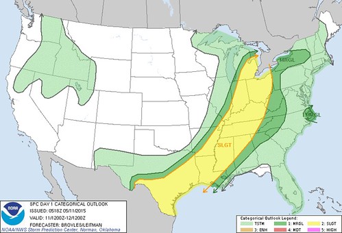
Storm Prediction Center
- As of early this morning our region was still under a Slight Risk for severe weather. The SPC will issue an updated convective outlook later this morning. We'll know then if our area will be upgraded to an Enhanced Risk.
- If conditions warrant, I'm guessing that the SPC will issue a Mesoscale Discussion for the region between Noon and 3:00 p.m. The MD will mention the likelihood of a watch being issues.
- If a watch is issued, I'm guessing that it will be issued between 1:00 and 3:00 p.m.
Early a.m. CO
spc ac 110518
day 1 convective outlook
nws storm prediction center norman ok
1218 am cdt mon may 11 2015
valid 111200z - 121200z
...there is a slgt risk of svr tstms across parts of the srn
plains...lower to mid ms valley...tn valley...oh valley...sern great
lakes...
...there is a mrgl risk of svr tstms across parts of the srn
plains...lower to mid ms valley...tn valley...oh valley...sern great
lakes...
...there is a mrgl risk of svr tstms across parts of ern nc...
...summary...
scattered thunderstorms are expected to develop along and ahead of a
cold front from lower michigan to central texas. isolated damaging
winds and hail will be possible with the stronger thunderstorms. a
couple tornadoes may occur in the southern great lakes region.
...srn great lakes/oh valley/mid ms valley...
an upper-level trough will move into the mid mo valley today as a
cold front advances ewd across the mid to upper ms valley.
thunderstorms will likely be ongoing ahead of the front in the mid
ms valley at the start of the period. this activity is forecast to
spread quickly newd across the lower oh valley into the srn great
lakes region by early afternoon. a corridor of instability is
forecast to develop ahead of this convection by early afternoon from
ern indiana and ohio nwd into sern lower mi. forecast soundings from
nrn oh nwd to near detroit mi at 21z show sfc dewpoints in the lower
60s f contributing to sbcape near 1500 j/kg. in
addition...directional shear is present from the sfc to 700 mb with
wind speeds increasing with height in the mid levels...creating
moderate deep-layer shear. this should be favorable for rotating
storms and possibly a couple tornadoes as a 40 to 55 kt low-level
jet moves across the region during the mid to late afternoon.
rotating storms and organized line segments may also produce wind
damage.
further to the east across much of new york...the models develop an
east-to-west axis of instability along and just to the south of a
warm front. scattered thunderstorm development should take place
along the front during the afternoon. instability may be enough
combined with unidirectional wind profiles for marginally severe
wind gusts.
...srn plains/arklatex/lower ms valley...
the srn extent of an upper-level trough will move ewd across the srn
plains today as a cold front advances sewd into the arklatex and tx
hill country. ahead of the boundary...sfc dewpoints from the mid 60s
to the lower 70s f should be in place...contributing to moderate to
strong destabilization by afternoon. thunderstorm development should
take place along and ahead from the front from the tx hill country
ewd into the lower ms valley. forecast soundings along this corridor
at 00z/tue show mlcape values generally in the 2000 to 2500 j/kg
range with 30 to 35 kt of deep-layer shear. this combined with steep
lapse rates should be favorable for some severe storms with
large-hail potential. supercells will be possible where deep-layer
shear becomes locally enhanced but multicells are expected to be the
most common storm type. in addition to the hail threat...a
wind-damage threat should exist with storms that rotate and the more
persistent line segments.
...ern nc...
tropical depression ana is forecast to move newd from ne nc into
sern va this morning. strong wind fields to the east of the center
may be enough for marginally severe wind gusts with convection that
develops across the cape hatteras area and further inland across ne
nc.
..broyles/leitman.. 05/11/2015
click to get wuus01 ptsdy1 product
note: the next day 1 outlook is scheduled by 1300z
SPC CO May 7-11
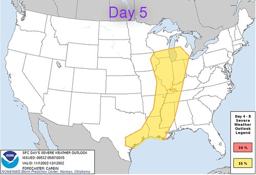
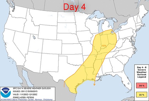
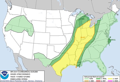
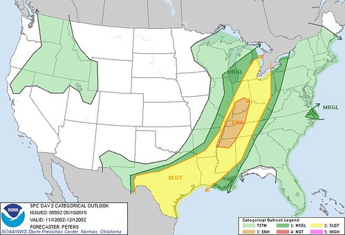
All of these convective outlooks were for Mon, May 11. The SPC has shown northwest Ohio to be in the risk of severe weather since Thu, May 7.
Day 5 convective outlook issued on Thu, May 7 for Mon, May 11
Day 4 convective outlook issued on Fri, May 8 for Mon, May 11
Day 3 convective outlook issued on Sat, May 9 for Mon, May 11
Day 2 convective outlook issued on Sun, May 10 for Mon, May 11
Day 1 convective outlook issued on Mon, May 11 for Mon, May 11
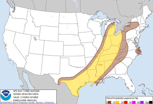
Wind outlook
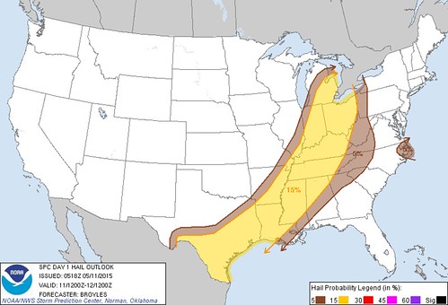
Hail outlook
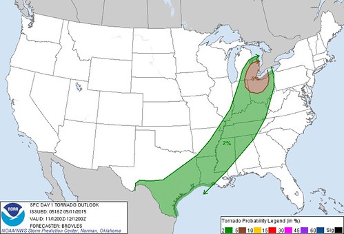
Tornado outlook
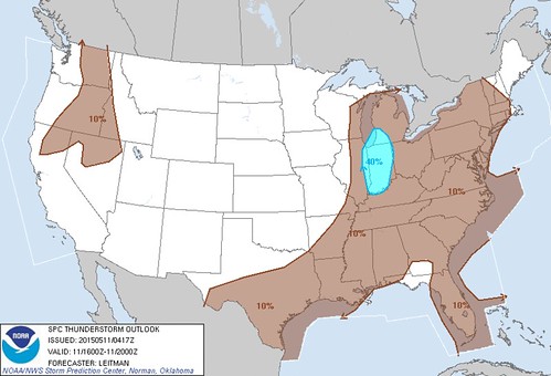
Thunderstorm outlook between 12:00 p.m. and 4:00 p.m.
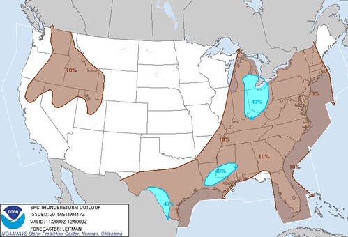
Thunderstorm outlook between 4:00 p.m. and 8:00 p.m.
From JR's : articles
1242 words - 7409 chars
- 6 min read
created on
updated on
- #
source
- versions
Related articles
Severe weather threat for Sun, Nov 17, 2013 - Nov 18, 2013
Nov 17, 2013 Toledo area weather notes - Mar 03, 2014
Posts related to Nov 17, 2013 severe weather - Nov 21, 2013
Toledo area weather for early December 2013 - Dec 05, 2013
Mon, Dec 9, 2013 winter storm forecast for Sat, Dec 14 - Dec 14, 2013
more >>