• Severe Weather Summary
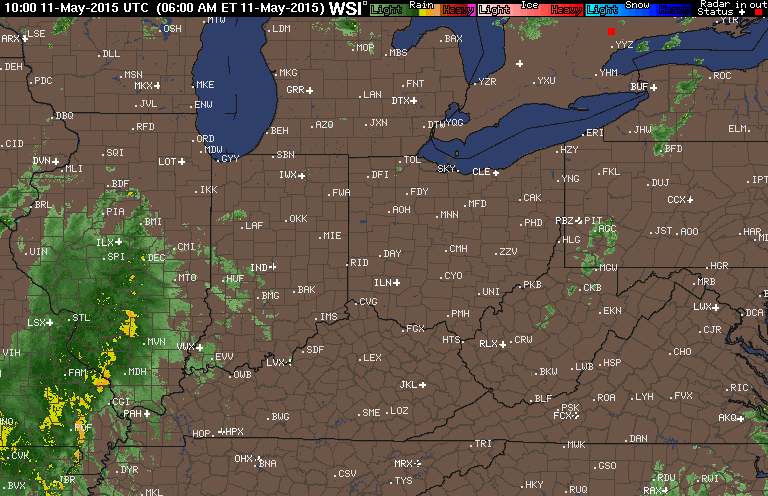
• Early a.m. CO
• SPC CO May 7-11
• 8:00 a.m. images
• Forecast
• AFD
You're viewing old version number 24. - Current version
Toledo Weather - Mon, May 11, 2015
hazardous weather outlook
national weather service cleveland oh
422 am edt mon may 11 2015
for lake erie...north central
ohio...northeast ohio...northwest ohio and northwest pennsylvania.
.day one...today and tonight.
there is a slight risk for severe thunderstorms today and early
tonight. the primary threat will be strong damaging winds and
large hail.
.days two through seven...tuesday through sunday.
no hazardous weather is expected at this time.
.spotter information statement...
spotter activation is not expected at this time.
$$
Toledo Airport Conditions
Toledo Express
May 11, 2015 5:52 am
Weather : Fog/Mist
Temperature : 64 F
Humidity : 96%
Wind Speed : Calm
Barometer : 29.93 in
Dewpoint: 63 F
Visibility : 5.00 statute miles
External Link : 3-day history
(formerly Metcalf Airport)
May 11, 2015 5:53 am
Weather : Partly Cloudy
Temperature : 66 F
Humidity : 90%
Wind Speed : S 5 mph
Barometer : 29.94 in
Dewpoint: 63 F
Visibility : 10.00 statute miles
(near Lambertville)
May 11, 2015 6:35 am
Weather : Fog/Mist
Temperature : 63 F
Humidity : 94%
Wind Speed : Calm
Barometer : 29.94 in
Dewpoint: 61 F
Visibility : 1.25 statute miles
TOL:
May 11, 2015 6:52 am
Weather : Fog/Mist
Temperature : 65 F
Humidity : 97%
Wind Speed : SSW 5 mph
Barometer : 29.95 in
Dewpoint: 64 F
Visibility : 6.00 statute miles
TOL:
May 11, 2015 7:52 am
Weather : Fair
Temperature : 66 F
Humidity : 87%
Wind Speed : SW 8 mph
Barometer : 29.97 in
Dewpoint: 62 F
Visibility : 10.00 statute miles
TOL:
May 11, 2015 8:52 am
Weather : Fair
Temperature : 68 F
Humidity : 81%
Wind Speed : SSW 6 mph
Barometer : 29.97 in
Dewpoint: 62 F
Visibility : 10.00 statute miles
(formerly Metcalf Airport)
May 11, 2015 8:53 am
Weather : Fair
Temperature : 70 F
Humidity : 76%
Wind Speed : SW 12 mph
Barometer : 29.99 in
Dewpoint: 62 F
Visibility : 10.00 statute miles
(near Lambertville)
May 11, 2015 8:54 am
Weather : Fair
Temperature : 70 F
Humidity : 78%
Wind Speed : SW 5 mph
Barometer : 29.98 in
Dewpoint: 63 F
Visibility : 10.00 statute miles
Severe Weather Summary
Areas with the best chance for severe weather
- northeast Indiana
- southern Michigan
- northwest Ohio
Main window for severe weather
- between 3:00 p.m. and 9:00 p.m.
- first line: between 4:00 p.m. and 6:00 p.m.
- second line: between 6:00 p.m. and 8:00 p.m.
Primary threats
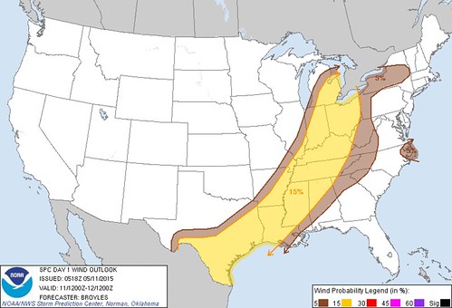
- Thunderstorm wind gusts of 60-plus mph, capable of downing trees and wires and possibly causing structural damage.
- Brief but torrential rainfall, capable of producing flash flooding.
Secondary threats
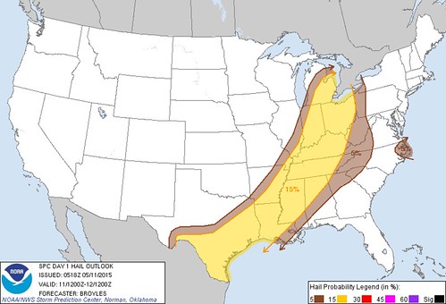
- Hail at least 3/4-inch in diameter
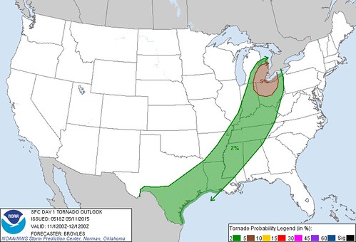
- Small tornadoes
Key ingredient
- Amount of sunshine this morning and early this afternoon.
- If the sky clears this morning, and we have a mostly sunny day, then our temps will warm into the low to mid 80s with dew points in the mid 60s, and the severe threat increases. The storm strength will depend upon the other atmospheric variables.
- At 6:00 a.m., our sky cover was at least 80%, comprised of low and mid level clouds. Muggy walk.
- At 8:00 a.m., our sky cover was around 50%. High and mid level cloudiness. Mostly sunny sky.
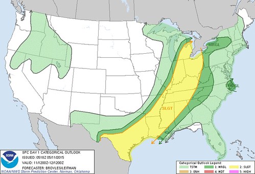
Storm Prediction Center
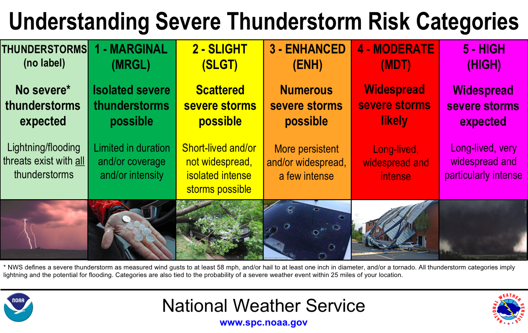
- As of early this morning our region was still under a Slight Risk for severe weather. The SPC will issue an updated convective outlook later this morning. We'll know then if our area will be upgraded to an Enhanced Risk.
- If conditions warrant, I'm guessing that the SPC will issue a Mesoscale Discussion for the region between Noon and 3:00 p.m. The MD will mention the likelihood of a watch being issues.
- If a watch is issued, I'm guessing that it will be issued between 1:00 and 3:00 p.m.
Early a.m. CO
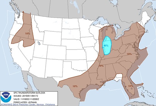
spc ac 110518
day 1 convective outlook
nws storm prediction center norman ok
1218 am cdt mon may 11 2015
valid 111200z - 121200z
...there is a slgt risk of svr tstms across parts of the srn
plains...lower to mid ms valley...tn valley...oh valley...sern great
lakes...
...there is a mrgl risk of svr tstms across parts of the srn
plains...lower to mid ms valley...tn valley...oh valley...sern great
lakes...
...there is a mrgl risk of svr tstms across parts of ern nc...
...summary...
scattered thunderstorms are expected to develop along and ahead of a
cold front from lower michigan to central texas. isolated damaging
winds and hail will be possible with the stronger thunderstorms. a
couple tornadoes may occur in the southern great lakes region.
...srn great lakes/oh valley/mid ms valley...
an upper-level trough will move into the mid mo valley today as a
cold front advances ewd across the mid to upper ms valley.
thunderstorms will likely be ongoing ahead of the front in the mid
ms valley at the start of the period. this activity is forecast to
spread quickly newd across the lower oh valley into the srn great
lakes region by early afternoon. a corridor of instability is
forecast to develop ahead of this convection by early afternoon from
ern indiana and ohio nwd into sern lower mi. forecast soundings from
nrn oh nwd to near detroit mi at 21z show sfc dewpoints in the lower
60s f contributing to sbcape near 1500 j/kg. in
addition...directional shear is present from the sfc to 700 mb with
wind speeds increasing with height in the mid levels...creating
moderate deep-layer shear. this should be favorable for rotating
storms and possibly a couple tornadoes as a 40 to 55 kt low-level
jet moves across the region during the mid to late afternoon.
rotating storms and organized line segments may also produce wind
damage.
further to the east across much of new york...the models develop an
east-to-west axis of instability along and just to the south of a
warm front. scattered thunderstorm development should take place
along the front during the afternoon. instability may be enough
combined with unidirectional wind profiles for marginally severe
wind gusts.
...srn plains/arklatex/lower ms valley...
the srn extent of an upper-level trough will move ewd across the srn
plains today as a cold front advances sewd into the arklatex and tx
hill country. ahead of the boundary...sfc dewpoints from the mid 60s
to the lower 70s f should be in place...contributing to moderate to
strong destabilization by afternoon. thunderstorm development should
take place along and ahead from the front from the tx hill country
ewd into the lower ms valley. forecast soundings along this corridor
at 00z/tue show mlcape values generally in the 2000 to 2500 j/kg
range with 30 to 35 kt of deep-layer shear. this combined with steep
lapse rates should be favorable for some severe storms with
large-hail potential. supercells will be possible where deep-layer
shear becomes locally enhanced but multicells are expected to be the
most common storm type. in addition to the hail threat...a
wind-damage threat should exist with storms that rotate and the more
persistent line segments.
...ern nc...
tropical depression ana is forecast to move newd from ne nc into
sern va this morning. strong wind fields to the east of the center
may be enough for marginally severe wind gusts with convection that
develops across the cape hatteras area and further inland across ne
nc.
..broyles/leitman.. 05/11/2015
click to get wuus01 ptsdy1 product
note: the next day 1 outlook is scheduled by 1300z
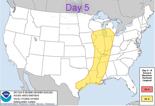
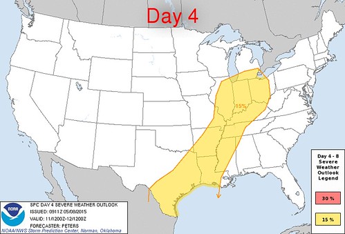
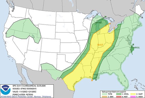
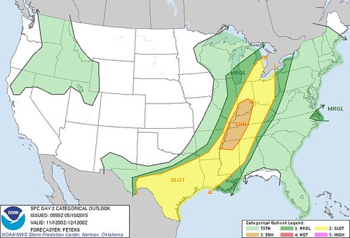
SPC CO May 7-11
All of these convective outlooks were for Mon, May 11. The SPC has shown northwest Ohio to be in the risk of severe weather since Thu, May 7.
Day 5 convective outlook issued on Thu, May 7 for Mon, May 11
Day 4 convective outlook issued on Fri, May 8 for Mon, May 11
Day 3 convective outlook issued on Sat, May 9 for Mon, May 11
Day 2 convective outlook issued on Sun, May 10 for Mon, May 11
Day 1 convective outlook issued on Mon, May 11 for Mon, May 11
Wind outlook
Hail outlook
Tornado outlook
Thunderstorm outlook between 12:00 p.m. and 4:00 p.m.
Thunderstorm outlook between 4:00 p.m. and 8:00 p.m.
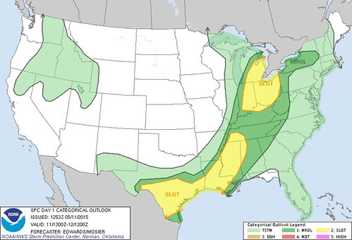
Updated Day 1 Convective Outlook. No upgrade to enhanced.
Map of low pressures and fronts. Good migrating songbird activity around our home this morning. The weather may have made for a big movement overnight. Need to check BSBO banding data to see how big today ends up being.
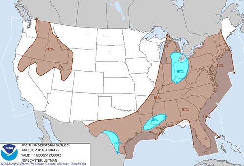
spc ac 111253
day 1 convective outlook
nws storm prediction center norman ok
0753 am cdt mon may 11 2015
valid 111300z - 121200z
...there is a slgt risk of svr tstms portions sern lower
mi...oh...indiana...nrn ky...
...there is a slgt risk of svr tstms portions mid south across lower
ms valley to s tx...
...there is a mrgl risk of svr tstms elsewhere from s tx to portions
wrn/nrn ny...
...summary...
scattered thunderstorms are expected to develop along and ahead of a
cold front over parts of lower michigan to the ohio valley...as well
as from the mid south to south texas. damaging winds and hail will
be possible with the stronger thunderstorms. a couple of tornadoes
may occur in the southern great lakes region.
...synopsis...
progressive mid/upper-level pattern is fcst through
period...featuring cyclones now evident in moisture-channel imagery
over ern dakotas and offshore pac nw. nrn-plains cyclone is
expected to move generally ewd across mn today...devolving into
open-wave trough tonight across wi. this will occur as accompanying
shortwave trough now over central high plains pivots ewd over ks/neb
then newd across lm and lower mi...and another perturbation pivots
sewd/ewd out of black hills region and across mid-upper ms valley.
pac cyclone will move sewd to swrn ore and nwrn ca through
period...and srn-stream perturbation now seen off baja will eject
enewd across nwrn mex toward far w tx and big bend region.
at sfc...cyclone now over srn mn is expected to move enewd across
wrn/nrn wi by 00z...then occlude...with new low ejecting enewd
across swrn que during 09-12z time frame. cold front...now extending
from upper ms valley across ozarks to central/sw tx...is preceded
along much of its length by convectively generated
outflow/baroclinic boundary that is evident from srn il to nrn la
and se tx. front itself should decelerate over s-central/se
tx...perhaps merging with prefrontal boundary this aftn or
overnight. cold front should move ewd to lower mi...indiana and
central/ern ar by 00z...then to ern ny...central/srn appalachians
and central ms around end of period. warm front should move nwd
today through parts of wi...lm and lower mi ahead of sfc
cyclone...and more slowly move nwd across wrn/nrn ny.
...s tx to lower ms valley...
ref spc ww 163 and related mesoscale discussions for near-term info
on svr threat over s tx.
additional svr-tstm development is possible today over this corridor
as air mass destabilizes in preconvective sector...including
potential re-intensification of currently/mostly anafrontal squall
line now evident from sern ar to se tx. damaging wind will be
possible...and large-hail threat increases with wwd extent across s
tx in proximity to steeper deep-layer lapse rates and larger diurnal
cape.
although mid/upper-level trough will be ejecting away from this
area...leading to height rises...subtle impulses embedded within
swly subtropical plume...combined with continued advection of eml
off higher terrain of nrn mex...will help to maintain steep lapse
rates aloft. meanwhile...combination of more direct lift from four
primary sources should support potential for convective development
across this swath today...
1. cold pools from any ongoing convection...especially la/se tx
sector...
2. leftover outflow boundary/boundaries and related
differential-heating zones extending from la/se tx tstm area swwd
across s tx...
3. front...especially where it can access suitably unstable
warm-sector air through gaps or mesobeta-scale recovery zones behind
morning convection. s tx seems most probable for this process.
4. sfc diabatic heating and related differential-heating zones.
svr potential should diminish late this evening over s-central/sw tx
and with offshore movement of leading squall line farther e today.
...great lakes/oh valley region to mid south...
one or more bkn bands of tstms are expected to develop through aftn
and move newd across this region...offering primarily damaging-gust
risk with a couple tornadoes also possible. although mid-upper
level lapse rates will be mrgl...sufficient moistening has occurred
such that cooling aloft shear of ejecting cyclone...combined with
pockets of diurnal sfc heating...will yield supportive instability.
mucape 500-1000 j/kg is possible...amidst 45-60 kt effective-shear
magnitudes. sufficient component of mean-wind and deep-shear
vectors across convective-band orientation is evident to suggest
discrete storm modes as well..increasing probabilities for a few
sustained supercells compared to areas farther s ahead of sfc cold
front.
relative min in svr potential is apparent between these two areas
across lower oh valley and parts of mid south...where convergence
along and ahead of cold front will be relatively minimized due to
boundary-layer veering in preconvective sector...and convective
plume has outpaced substantial waa/moisture-advection-related
destabilization. in addition...cloud cover will limit diabatic sfc
heating over this area.
...ern nc/sern va...
remnants of td ana will proceed newd across ern sc and offshore
hampton roads region through this evening. due to weakness of both
instability and low-level shear...and lack of substantial convective
structures...in weakening system...svr probabilities have been
dropped.
..edwards/mosier.. 05/11/2015
click to get wuus01 ptsdy1 product
note: the next day 1 outlook is scheduled by 1630z
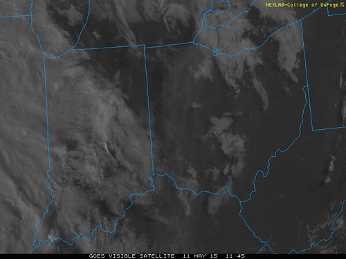
8:00 a.m. images
It appears that we'll have a mostly sunny sky until around Noon to 2:00 p.m. The first line of storms may reach around 2:00 to 4:00 p.m., and they may be the strongest.
Forecast
Toledo 7-day forecast
Last Update: May 11, 2015 6:10 am
Today: Showers and thunderstorms, mainly after 2pm. High near 81. South wind 8 to 15 mph, with gusts as high as 32 mph. Chance of precipitation is 80%. New rainfall amounts between a tenth and quarter of an inch, except higher amounts possible in thunderstorms.
Tonight: Showers and thunderstorms, mainly before 2am, then a slight chance of thunderstorms after 4am. Low around 55. Southwest wind 11 to 17 mph. Chance of precipitation is 80%. New rainfall amounts between a tenth and quarter of an inch, except higher amounts possible in thunderstorms.
Tuesday: A slight chance of showers. Increasing clouds, with a high near 63. Breezy, with a west wind 16 to 23 mph. Chance of precipitation is 20%.
Tuesday Night: Mostly cloudy, with a low around 41. West wind 11 to 18 mph.
Wednesday: Partly sunny, with a high near 59. Northwest wind 9 to 11 mph.
Wednesday Night: Partly cloudy, with a low around 42.
Thursday: Mostly sunny, with a high near 66.
Thursday Night: Mostly cloudy, with a low around 48.
Friday: A chance of showers. Mostly cloudy, with a high near 69. Chance of precipitation is 40%.
Friday Night: A chance of showers. Mostly cloudy, with a low around 55. Chance of precipitation is 40%.
Saturday: Mostly cloudy, with a high near 72.
Saturday Night: Mostly cloudy, with a low around 57.
Sunday: Partly sunny, with a high near 79.
AFD
fxus61 kcle 111142
afdcle
area forecast discussion
national weather service cleveland oh
742 am edt mon may 11 2015
synopsis...
low pressure over minnesota will move into eastern canada by tuesday
dragging a series of cold fronts across the area early tonight
through tuesday. high pressure will move east across the region
wednesday night and thursday then a weak low will move across the
southern part of the lakes along a warm front lifting north.
&&
near term /until 6 pm this evening/...
enough upper ridging should hang on over the area for much of the
day to limit convective coverage. by late in the day...the approach
of a cold front...increased wind shear and improving upper dynamics
should start to improve the chances for more widespread convection
along with the possibility for severe storms. the ongoing forecast
seems to have good handle on situation with ramp up in pops from
west to east starting late in the day.
one more very warm day in store before below normal temps return.
highs should mainly run in the low to mid 80s.
&&
short term /6 pm this evening through thursday night/...
the first in a series of cold fronts should bring a band of strong
to locally severe convection to the area as it sweeps west to east
across the cwa. drier air quickly punches in behind the first front
so most of the shra/tsra should be done with the first front leaving
only widely sct shra left later in the night with the second front.
on tue into tue night....the upper trough works east across lake
erie with another reinforcing cold front. much of the deeper
moisture stays over lake erie so expect sct light shra...especially
for the ne lakeshore. tue should be a fairly windy day with winds of
20 to 25 mph with gusts to 40 mph. temps should rise only a few
degrees on tue due to widespread clouds and the cold advection.
most of the shra should taper off tue night from west to east but a
few could linger in nw pa for a while wed morning. lows tue night
tricky due to uncertainty as to how quickly the cloud cover start to
dissipate.
cold air aloft will act to produce additional daytime cu on wed then
high pressure moves over the area for wed night. highs on wed will
probably only range from around 60 in the sw to only around 50 in
the ne. the cu field should dissipate in the evening and winds
become light. this will set up a good radiational cooling night.
concerned that guidance temps may not be cold enough and that some
frost may occur so will trim guidance temps a little.
high pressure will hang on for thu so a dry day in store. temps
should moderate some but the models show a lot of high
moisture/cirrus moving into the region ahead of the next system in
the plains. the expected cirrus should help to keep lows in the 40s
thu night.
a southerly return flow should set up thu night and lower level
moisture will start to increase. this may allow to some shra to push
into the west part of the cwa by the latter part of the night. will
divide the forecast for thu night to better show an increase in pop
by the end of the night for the west.
&&
long term /friday through sunday/...
by friday the high will have slid off to the east and warmer and
more moist flow will return for the weekend. upper ridge will break
down some as fairly well agreed upon shortwave tops it as it crosses
the lower great lakes at the end of the work week. will continue the
rain chances friday/friday night. have lingered chances into
saturday with some semblance of a surface front in the vicinity.
precip chances return again sunday night as a warm front will be
lifting northward. overall will be returning to above normal
temperatures for the weekend.
&&
aviation /12z monday through friday/...
unsettled weather with a strong storm system moving through the
region. aviation impacts will primarily be from thunderstorms
later this afternoon and evening. light southerly winds today will
increase...with gusts of 20 to 30 knots possible outside of
thunderstorms...especially for tol/fdy/mfd/cle. vfr to start the
day. a cold front will be crossing the area this evening...with an
active prefrontal trough ahead of it. some of these thunderstorms
may produce winds in excess of 45 knots and of course non vfr
conditions. may have some mvfr cigs develop in the wake of the
cold front monday night. southwest gusts on tuesday in excess of
30 knots likely.
outlook...non vfr possible monday night. mvfr ceilings possible
extreme ne oh/nw pa wednesday. non vfr possible again friday.
&&
marine...
light/variable flow to start the morning on the lake will become
southerly today as a warm front lifts north of the lake. showers and
thunderstorms will accompany a cold front for later this afternoon
and evening. some of these storms may be strong with gusty winds.
otherwise winds will pick up on the lake behind the front tonight
and continue from a southwesterly direction on tuesday. winds will
definitely be enough for small craft advisory on tuesday into
wednesday. will top winds out at 25 or 30 knots tuesday...with the
peak in cold air advection occurring. winds slowly subside going
into mid week as high pressure passes overhead. the high shifts east
by friday allowing for southerly flow.
&&
cle watches/warnings/advisories...
oh...none.
pa...none.
marine...none.
&&
$$
synopsis...adams
near term...adams
short term...adams
long term...oudeman
aviation...oudeman
marine...oudeman
http://www.spc.noaa.gov/misc/SPC_5-tier_Convective_Outlook_Info_files/understanding_categories.png
From JR's : articles
3408 words - 20776 chars
- 18 min read
created on
updated on
- #
source
- versions
Related articles
Severe weather threat for Sun, Nov 17, 2013 - Nov 18, 2013
Nov 17, 2013 Toledo area weather notes - Mar 03, 2014
Posts related to Nov 17, 2013 severe weather - Nov 21, 2013
Toledo area weather for early December 2013 - Dec 05, 2013
Mon, Dec 9, 2013 winter storm forecast for Sat, Dec 14 - Dec 14, 2013
more >>