You're viewing old version number 15. - Current version
Toledo weather sat jun 27 2015 - Part 2
http://jothut.com/cgi-bin/junco.pl/replies/56524
http://jothut.com/cgi-bin/junco.pl/blogpost/56513/27Jun2015/Toledo-weather-sat-jun-27-2015
Just before 4:00 p.m., Jun 27, 2015
we were out and about from approx 11:30 a.m. to 3:00 p.m. when we got home, a small-medium branch fell on our driveway apron from the silver maple tree on the devil's strip. the branch popped lose the electrical wire from our house. the bracket got pulled out from the house. dd called toledo edison. the wire is draped along our front yard and the public sidewalk. it's low over the street but cars could drive under it.
at about 4:00 p.m., a TPD officer stopped on the street to block traffic. i spoke with the officer. he said power outages exists around the city for similar things. he also said that many streets were flooded, including Douglas and The Trail. The police had to erect barricades because drivers were still attempting to drive through the water and the vehicles were stalling.
my rss feed as of 4:03 p.m.:
http://jothut.com/cgi-bin/junco.pl/blogpost/55643/22Jun2015/Nws-feeds
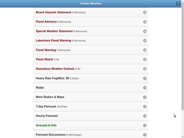
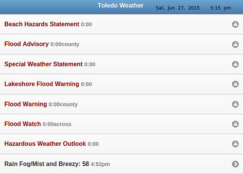
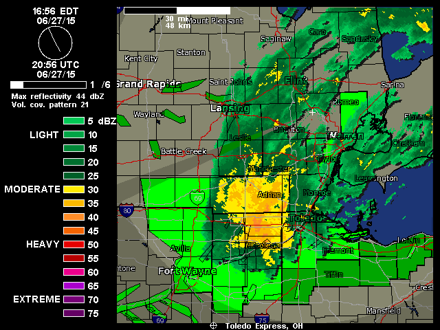
Toledo Weather Messages - 2015-06-27T20:06:03Z
- Flood Watch - 2015-06-27T15:46:00-04:00
- Flood Warning - 2015-06-27T15:42:00-04:00
- Flood Advisory - 2015-06-27T14:01:00-04:00
- Special Weather Statement - 2015-06-27T13:15:00-04:00
- Lakeshore Flood Warning - 2015-06-27T10:06:00-04:00
- Beach Hazards Statement - 2015-06-27T10:06:00-04:00
- Hazardous Weather Outlook - 2015-06-27T20:06:03Z
Event: Flood Watch
Alert:
...FLOOD THREAT CONTINUES INTO TONIGHT...
STEADY MODERATE TO OCCASIONALLY HEAVY RAIN WILL CONTINUE THIS
EVENING ACROSS NORTHWEST OHIO. ACROSS NORTHEAST OHIO AND NORTHWEST
PENNSYLVANIA SHOWERS AND SOME THUNDERSTORMS WILL STILL BE ABLE TO
PRODUCE HEAVY RAINFALL. AN ADDITIONAL INCH TO AN INCH AND A HALF
OF RAINFALL IS POSSIBLE. ACROSS NORTH CENTRAL OHIO RAIN WILL BE
RETURNING TO THE AREA LATER THIS EVENING. RUNOFF CONTINUES FROM
EARLIER RAINFALL.
THIS AMOUNT OF RAINFALL WILL BE EXCESSIVE AND LEAD TO FLOODING IN
SOME AREAS THROUGH TONIGHT.
...FLOOD WATCH REMAINS IN EFFECT THROUGH LATE TONIGHT...
THE FLOOD WATCH CONTINUES FOR
* PORTIONS OF OHIO AND NORTHWEST PENNSYLVANIA...INCLUDING THE
FOLLOWING AREAS...IN OHIO...ASHTABULA INLAND...ASHTABULA
LAKESHORE...CUYAHOGA...ERIE OH...GEAUGA...HANCOCK...HURON...
LAKE...LORAIN...LUCAS...MAHONING...OTTAWA...PORTAGE...
SANDUSKY...SENECA...TRUMBULL AND WOOD. IN NORTHWEST
PENNSYLVANIA...CRAWFORD PA...NORTHERN ERIE AND SOUTHERN ERIE.
* THROUGH LATE TONIGHT.
* A SLOW MOVING LOW PRESSURE SYSTEM WILL REMAIN ACROSS THE AREA
TONIGHT...SLOWLY EXITING TO THE EAST ON SUNDAY. STEADY RAINFALL
IS EXPECTED IN NORTHWEST OHIO WITH PERIODS OF SHOWERS AND
THUNDERSTORMS IN NORTH CENTRAL AND NORTHEAST OHIO AND NORTHWEST
PENNSYLVANIA. WIDESPREAD RAINFALL OF 2.0 TO 3.0 INCHES OF RAIN
WILL HAVE FALLEN FROM LAST NIGHT THROUGH LATE TONIGHT. LOCALLY
HIGHER AMOUNTS ARE POSSIBLE. GIVEN THE RECENT WET CONDITIONS...
FLOODING WILL LIKELY DEVELOP IN SOME AREAS.
* FLOODING...ESPECIALLY IN URBAN AREAS...CAN OCCUR VERY
QUICKLY...PRIMARILY AT UNDERPASSES AND POOR DRAINAGE AREAS.
RISES ON AREA CREEKS AND STREAMS WILL OCCUR AND MAY BE RUNNING
AT HIGH CAPACITY FROM THE HEAVY RAINFALL.
Instructions: A FLOOD WATCH MEANS THERE IS A POTENTIAL FOR FLOODING BASED ON CURRENT FORECASTS. YOU SHOULD MONITOR LATER FORECASTS AND BE ALERT FOR POSSIBLE FLOOD WARNINGS. THOSE LIVING IN AREAS PRONE TO FLOODING SHOULD BE PREPARED TO TAKE ACTION SHOULD FLOODING DEVELOP. STAY TUNED TO WEATHER RADIO FOR FURTHER DETAILS OR UPDATES
:
THE NATIONAL WEATHER SERVICE IN CLEVELAND HAS ISSUED A
* FLOOD WARNING FOR URBAN AREAS AND SMALL STREAMS IN...
WOOD COUNTY IN NORTHWESTERN OHIO...
LUCAS COUNTY IN NORTHWESTERN OHIO...
* UNTIL 345 PM EDT SUNDAY
* AT 339 PM EDT...DOPPLER RADAR INDICATED HEAVY RAIN THAT WILL CAUSE
FLOODING. TWO TO THREE INCHES OF RAIN HAS FALLEN OVER MUCH OF THE
AREA SINCE YESTERDAY EVENING. ANOTHER INCH OF RAIN IS LIKELY FOR
MANY AREAS THROUGH TONIGHT.
* SOME LOCATIONS THAT WILL EXPERIENCE FLOODING INCLUDE...
BOWLING GREEN...FOSTORIA...PERRYSBURG...OREGON...SYLVANIA...
ROSSFORD...WATERVILLE...NORTHWOOD...WHITEHOUSE...NORTH BALTIMORE...
HOLLAND...WESTON...MAUMEE...OTTAWA HILLS...WALBRIDGE...
PEMBERVILLE...MILLBURY...HASKINS...LUCKEY AND BRADNER.
Instructions: EXCESSIVE RUNOFF FROM HEAVY RAINFALL WILL CAUSE FLOODING OF SMALL CREEKS AND STREAMS...HIGHWAYS AND UNDERPASSES IN URBAN AREAS. ADDITIONALLY...COUNTRY ROADS AND FARMLANDS ALONG THE BANKS OF CREEKS...STREAMS AND OTHER LOW LYING AREAS ARE SUBJECT TO FLOODING.
THE NATIONAL WEATHER SERVICE IN CLEVELAND HAS ISSUED A
* FLOOD ADVISORY FOR...
WOOD COUNTY IN NORTHWESTERN OHIO...
SANDUSKY COUNTY IN NORTHWESTERN OHIO...
LUCAS COUNTY IN NORTHWESTERN OHIO...
OTTAWA COUNTY IN NORTHWESTERN OHIO...
* UNTIL MIDNIGHT EDT SUNDAY
* AT 158 PM EDT...DOPPLER RADAR INDICATED HEAVY RAINFALL FROM
SHOWERS THAT HAVE BEEN OCCURRING SINCE LAST NIGHT. RAINFALL
AMOUNTS OF 1 TO 2 INCHES HAVE BEEN COMMON. THE CONTINUED SHOWERS
HAVE CAUSED LOW LYING AREAS TO FLOOD.
* SOME LOCATIONS THAT WILL EXPERIENCE FLOODING INCLUDE...
BOWLING GREEN...FREMONT...FOSTORIA...PORT CLINTON...PERRYSBURG...
OREGON...SYLVANIA...BELLEVUE...CLYDE...ROSSFORD...WATERVILLE...
NORTHWOOD...WHITEHOUSE...NORTH BALTIMORE...OAK HARBOR...
GIBSONBURG...GENOA...WOODVILLE...HOLLAND AND WESTON.
Instructions: MOST FLOOD DEATHS OCCUR IN AUTOMOBILES. NEVER DRIVE YOUR VEHICLE INTO AREAS WHERE THE WATER COVERS THE ROADWAY. FLOOD WATERS ARE USUALLY DEEPER THAN THEY APPEAR. JUST ONE FOOT OF FLOWING WATER IS POWERFUL ENOUGH TO SWEEP VEHICLES OFF THE ROAD. WHEN ENCOUNTERING FLOODED ROADS MAKE THE SMART CHOICE...TURN AROUND...DONT DROWN. EXCESSIVE RUNOFF FROM HEAVY RAINFALL WILL CAUSE PONDING OF WATER IN URBAN AREAS...HIGHWAYS...STREETS AND UNDERPASSES AS WELL AS OTHER POOR DRAINAGE AREAS AND LOW LYING SPOTS. DO NOT ATTEMPT TO TRAVEL ACROSS FLOODED ROADS. FIND ALTERNATE ROUTES.
Event: Special Weather Statement
Alert:
...GUSTY WINDS WILL AFFECT LUCAS...WOOD...OTTAWA...SANDUSKY...AND
ERIE COUNTIES THROUGH THIS AFTERNOON...
GUSTY NORTHEAST WINDS WILL CONTINUE THIS AFTERNOON. WHILE GUSTS TO
40 MPH WILL BE MOST COMMON...GUSTS TO 50 MPH WILL BE POSSIBLE.
THERE HAVE BEEN A FEW REPORTS OF TREES AND LIMBS DOWN IN THE
AREA DUE TO THE STRONG WINDS.
Event: Lakeshore Flood Warning
Alert:
...LAKESHORE FLOOD WARNING REMAINS IN EFFECT UNTIL 10 PM EDT THIS
EVENING...
...BEACH HAZARDS STATEMENT REMAINS IN EFFECT THROUGH SUNDAY
MORNING...
* LAKE SHORE FLOODING...STRONG NORTHEAST WINDS OF 35 TO 40 KNOTS
CONTINUE THROUGH THE EVENING.
* HAZARDS...COASTAL FLOODING AND DANGEROUS SWIMMING CONDITIONS.
* TIMING...DANGEROUS SWIMMING CONDITIONS WILL OCCUR THROUGH SUNDAY
MORNING. THE COASTAL FLOODING HAS BEEN MAINLY BEEN LOCATED ALONG
THE OTTAWA AND LUCAS COUNTY SHORELINES. THE FLOODING THREAT FROM
THE LAKE SHOULD DECREASE AS WINDS SHIFT TO THE NORTH AND
NORTHWEST THIS EVENING.
* LOCATION...THE LAKESHORE FROM FROM LUCAS COUNTY TO ERIE COUNTY
OHIO
* IMPACTS...LARGE WAVES WILL CAUSE RIP CURRENTS TO DEVELOP.
RISING WATER LEVELS DUE TO DRIVING WINDS MAY RESULT FLOODING
ALONG THE LAKESHORE.
Instructions: A LAKESHORE FLOOD WARNING MEANS LAKESHORE FLOODING IS OCCURRING... IS IMMINENT... OR IS EXPECTED TO OCCUR WITHIN THE NEXT 12 HOURS. PEOPLE IN THE WARNING AREA SHOULD TAKE IMMEDIATE ACTION TO PROTECT LIFE AND PROPERTY. LISTEN TO LOCAL RADIO...TELEVISION... OR NOAA WEATHER RADIO FOR FURTHER INFORMATION. SWIMMING RISK EXISTS TODAY. THE COMBINATION OF WIND AND OR WAVES WILL MAKE FOR POTENTIALLY DANGEROUS CONDITIONS FOR SWIMMERS INCLUDING THE RISK OF RIP CURRENTS. FOLLOW THE INSTRUCTION OF LOCAL AUTHORITIES OR STAY OUT OF THE WATER.
Event: Beach Hazards Statement
Alert:
...LAKESHORE FLOOD WARNING REMAINS IN EFFECT UNTIL 10 PM EDT THIS
EVENING...
...BEACH HAZARDS STATEMENT REMAINS IN EFFECT THROUGH SUNDAY
MORNING...
* LAKE SHORE FLOODING...STRONG NORTHEAST WINDS OF 35 TO 40 KNOTS
CONTINUE THROUGH THE EVENING.
* HAZARDS...COASTAL FLOODING AND DANGEROUS SWIMMING CONDITIONS.
* TIMING...DANGEROUS SWIMMING CONDITIONS WILL OCCUR THROUGH SUNDAY
MORNING. THE COASTAL FLOODING HAS BEEN MAINLY BEEN LOCATED ALONG
THE OTTAWA AND LUCAS COUNTY SHORELINES. THE FLOODING THREAT FROM
THE LAKE SHOULD DECREASE AS WINDS SHIFT TO THE NORTH AND
NORTHWEST THIS EVENING.
* LOCATION...THE LAKESHORE FROM FROM LUCAS COUNTY TO ERIE COUNTY
OHIO
* IMPACTS...LARGE WAVES WILL CAUSE RIP CURRENTS TO DEVELOP.
RISING WATER LEVELS DUE TO DRIVING WINDS MAY RESULT FLOODING
ALONG THE LAKESHORE.
Instructions: A LAKESHORE FLOOD WARNING MEANS LAKESHORE FLOODING IS OCCURRING... IS IMMINENT... OR IS EXPECTED TO OCCUR WITHIN THE NEXT 12 HOURS. PEOPLE IN THE WARNING AREA SHOULD TAKE IMMEDIATE ACTION TO PROTECT LIFE AND PROPERTY. LISTEN TO LOCAL RADIO...TELEVISION... OR NOAA WEATHER RADIO FOR FURTHER INFORMATION. SWIMMING RISK EXISTS TODAY. THE COMBINATION OF WIND AND OR WAVES WILL MAKE FOR POTENTIALLY DANGEROUS CONDITIONS FOR SWIMMERS INCLUDING THE RISK OF RIP CURRENTS. FOLLOW THE INSTRUCTION OF LOCAL AUTHORITIES OR STAY OUT OF THE WATER.
Hazardous Weather Outlook
HAZARDOUS WEATHER OUTLOOK
NATIONAL WEATHER SERVICE CLEVELAND OH
406 PM EDT SAT JUN 27 2015
OHZ003-007-009-282015-
LUCAS-OTTAWA-ERIE OH-
406 PM EDT SAT JUN 27 2015
...LAKESHORE FLOOD WARNING IN EFFECT UNTIL 10 PM EDT THIS EVENING...
...FLOOD WATCH IN EFFECT UNTIL 4 AM EDT SUNDAY...
...BEACH HAZARDS STATEMENT IN EFFECT FROM 10 PM EDT THIS EVENING
THROUGH SUNDAY MORNING...
THIS HAZARDOUS WEATHER OUTLOOK IS FOR NORTH CENTRAL OHIO AND
NORTHWEST OHIO.
.DAY ONE...TONIGHT.
PLEASE LISTEN TO NOAA WEATHER RADIO OR GO TO WEATHER.GOV ON THE
INTERNET FOR MORE INFORMATION ABOUT THE FOLLOWING HAZARDS.
LAKESHORE FLOOD WARNING.
FLOOD WATCH.
BEACH HAZARDS STATEMENT.
.DAYS TWO THROUGH SEVEN...SUNDAY THROUGH FRIDAY.
PLEASE LISTEN TO NOAA WEATHER RADIO OR GO TO WEATHER.GOV ON THE
INTERNET FOR MORE INFORMATION ABOUT THE FOLLOWING HAZARDS.
BEACH HAZARDS STATEMENT.
.SPOTTER INFORMATION STATEMENT...
REPORTS OF RAINFALL OR FLOODING ARE APPRECIATED.
$$
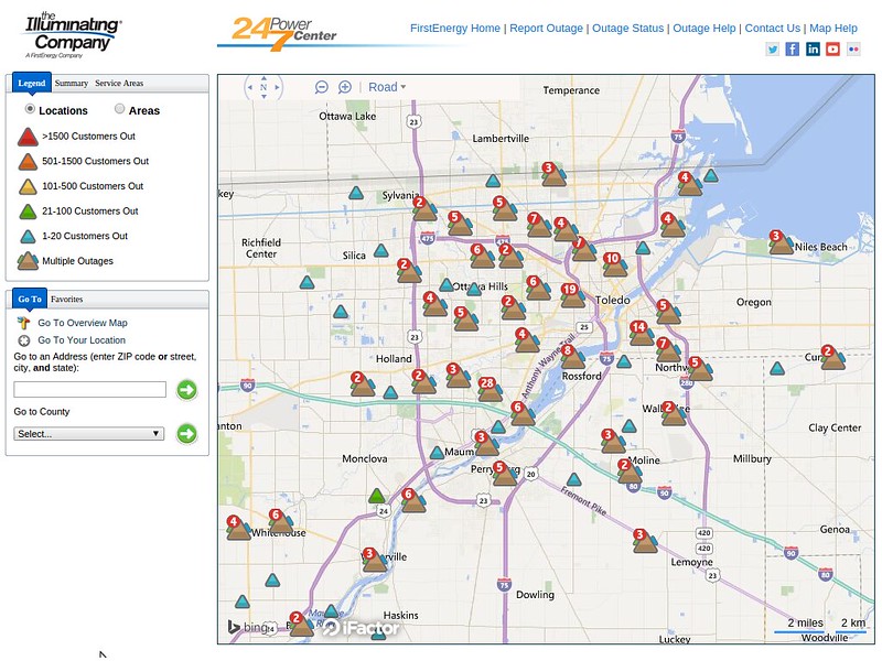
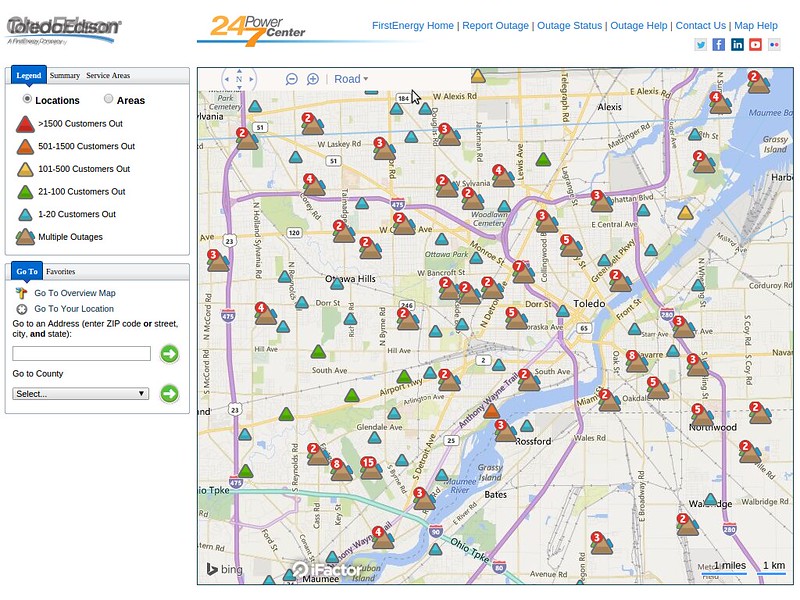
outage map as of 4:27 p.m.
lakeshore hazard message
national weather service cleveland oh
411 pm edt sat jun 27 2015
ohz003-007-009-280415-
/o.con.kcle.ls.w.0001.000000t0000z-150628t0200z/
/o.con.kcle.bh.s.0004.000000t0000z-150628t1300z/
lucas-ottawa-erie oh-
411 pm edt sat jun 27 2015
...lakeshore flood warning remains in effect until 10 pm edt this
evening...
...beach hazards statement remains in effect through sunday
morning...
- lake shore flooding...strong northeast winds of 35 to 40 knots
continue through the evening.
- hazards...coastal flooding and dangerous swimming conditions.
- timing...dangerous swimming conditions will occur through sunday
morning. the coastal flooding has been mainly been located along
the ottawa and lucas county shorelines. the flooding threat from
the lake should decrease as winds shift to the north and
northwest this evening.
- location...the lakeshore from from lucas county to erie county
ohio
- impacts...large waves will cause rip currents to develop.
rising water levels due to driving winds may result flooding
along the lakeshore.
precautionary/preparedness actions...
a lakeshore flood warning means lakeshore flooding is occurring...
is imminent... or is expected to occur within the next 12 hours.
people in the warning area should take immediate action to
protect life and property. listen to local radio...television...
or noaa weather radio for further information.
swimming risk exists today. the combination of wind and or waves
will make for potentially dangerous conditions for swimmers
including the risk of rip currents. follow the instruction of
local authorities or stay out of the water.
&&
$$
lakeshore flood warning
lakeshore hazard message
national weather service cleveland oh
411 pm edt sat jun 27 2015
ohz003-007-009-280415-
/o.con.kcle.ls.w.0001.000000t0000z-150628t0200z/
/o.con.kcle.bh.s.0004.000000t0000z-150628t1300z/
lucas-ottawa-erie oh-
411 pm edt sat jun 27 2015
...lakeshore flood warning remains in effect until 10 pm edt this
evening...
...beach hazards statement remains in effect through sunday
morning...
- lake shore flooding...strong northeast winds of 35 to 40 knots
continue through the evening.
- hazards...coastal flooding and dangerous swimming conditions.
- timing...dangerous swimming conditions will occur through sunday
morning. the coastal flooding has been mainly been located along
the ottawa and lucas county shorelines. the flooding threat from
the lake should decrease as winds shift to the north and
northwest this evening.
- location...the lakeshore from from lucas county to erie county
ohio
- impacts...large waves will cause rip currents to develop.
rising water levels due to driving winds may result flooding
along the lakeshore.
precautionary/preparedness actions...
a lakeshore flood warning means lakeshore flooding is occurring...
is imminent... or is expected to occur within the next 12 hours.
people in the warning area should take immediate action to
protect life and property. listen to local radio...television...
or noaa weather radio for further information.
swimming risk exists today. the combination of wind and or waves
will make for potentially dangerous conditions for swimmers
including the risk of rip currents. follow the instruction of
local authorities or stay out of the water.
&&
$$
hazardous weather outlook
hazardous weather outlook
national weather service cleveland oh
406 pm edt sat jun 27 2015
ohz003-007-009-282015-
lucas-ottawa-erie oh-
406 pm edt sat jun 27 2015
...lakeshore flood warning in effect until 10 pm edt this evening...
...flood watch in effect until 4 am edt sunday...
...beach hazards statement in effect from 10 pm edt this evening
through sunday morning...
this hazardous weather outlook is for north central ohio and
northwest ohio.
.day one...tonight.
please listen to noaa weather radio or go to weather.gov on the
internet for more information about the following hazards.
lakeshore flood warning.
flood watch.
beach hazards statement.
.days two through seven...sunday through friday.
please listen to noaa weather radio or go to weather.gov on the
internet for more information about the following hazards.
beach hazards statement.
.spotter information statement...
reports of rainfall or flooding are appreciated.
$$
flood watch
flood watch
national weather service cleveland oh
346 pm edt sat jun 27 2015
...flood threat continues into tonight...
steady moderate to occasionally heavy rain will continue this
evening across northwest ohio. across northeast ohio and northwest
pennsylvania showers and some thunderstorms will still be able to
produce heavy rainfall. an additional inch to an inch and a half
of rainfall is possible. across north central ohio rain will be
returning to the area later this evening. runoff continues from
earlier rainfall.
this amount of rainfall will be excessive and lead to flooding in
some areas through tonight.
ohz003-006>014-017>019-022-023-033-089-paz001>003-280500-
/o.con.kcle.fa.a.0003.000000t0000z-150628t0800z/
/00000.0.er.000000t0000z.000000t0000z.000000t0000z.oo/
lucas-wood-ottawa-sandusky-erie oh-lorain-cuyahoga-lake-geauga-
ashtabula inland-hancock-seneca-huron-portage-trumbull-mahoning-
ashtabula lakeshore-northern erie-southern erie-crawford pa-
including the cities of...toledo...bowling green...port clinton...
fremont...sandusky...lorain...cleveland...mentor...chardon...
jefferson...findlay...tiffin...norwalk...ravenna...warren...
youngstown...ashtabula...erie...edinboro...meadville
346 pm edt sat jun 27 2015
...flood watch remains in effect through late tonight...
the flood watch continues for
- portions of ohio and northwest pennsylvania...including the
following areas...in ohio...ashtabula inland...ashtabula
lakeshore...cuyahoga...erie oh...geauga...hancock...huron...
lake...lorain...lucas...mahoning...ottawa...portage...
sandusky...seneca...trumbull and wood. in northwest
pennsylvania...crawford pa...northern erie and southern erie.
- through late tonight.
- a slow moving low pressure system will remain across the area
tonight...slowly exiting to the east on sunday. steady rainfall
is expected in northwest ohio with periods of showers and
thunderstorms in north central and northeast ohio and northwest
pennsylvania. widespread rainfall of 2.0 to 3.0 inches of rain
will have fallen from last night through late tonight. locally
higher amounts are possible. given the recent wet conditions...
flooding will likely develop in some areas.
- flooding...especially in urban areas...can occur very
quickly...primarily at underpasses and poor drainage areas.
rises on area creeks and streams will occur and may be running
at high capacity from the heavy rainfall.
precautionary/preparedness actions...
a flood watch means there is a potential for flooding based on
current forecasts. you should monitor later forecasts and be
alert for possible flood warnings. those living in areas prone to
flooding should be prepared to take action should flooding
develop. stay tuned to weather radio for further details or
updates
around 4:30 p.m.
Summary:
Affected Customers: 5,184
Last Updated: Jun 27, 4:37 PM
special weather statement
national weather service cleveland oh
427 pm edt sat jun 27 2015
ohz003-006>009-280200-
lucas-wood-ottawa-sandusky-erie oh-
including the cities of...toledo...bowling green...port clinton...
fremont...sandusky
427 pm edt sat jun 27 2015
...gusty winds will affect lucas...wood...ottawa...sandusky...and
erie counties through the evening...
gusty north and northeast winds will continue into the
evening. while gusts to 40 mph will be most common...gusts to 50
mph will be possible. there have been a few reports of trees and
limbs down in the area due to the strong winds.
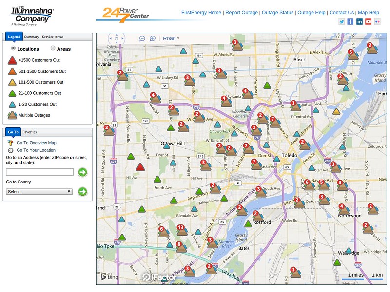
outage summary
Affected Customers: 5,626
Last Updated: Jun 27, 5:03 PM
TOL:
Jun 27, 2015 4:52 pm
Weather : Rain Fog/Mist and Breezy
Temperature : 58 F
Humidity : 97%
Wind Speed : NNW 23 mph - Gust 39 mph
Barometer : 29.70 in
Dewpoint: 57 F
Visibility : 1.75 statute miles
Affected Customers: 5,458
Last Updated: Jun 27, 5:26 PM
i emptied rain gauge again. this time at 5:40 p.m. it recorded 1.50 inches. that's a total of 2.90 inches.
I think LZ provides some practical info.
- If it keeps on rainin', Levee is gonna to break
- Cryin' won't help you, prayin' won't do you no good
- When the Levee breaks, mama, you got to move
- Going to Chicago
As of 5:40 p.m., my rain gauge has recorded 2.90 inches of rainfall for the day in West Toledo.
The Toledo area may have some issues.
Toledo Express Airport weather at about 5:00 p.m.
Jun 27, 2015 4:52 pm
Weather : Rain Fog/Mist and Breezy
Temperature : 58 F
Humidity : 97%
Wind Speed : NNW 23 mph - Gust 39 mph
Barometer : 29.70 in
Dewpoint: 57 F
Visibility : 1.75 statute miles
Many Toledo streets were flooded and some were closed.
The heavy rain and strong winds have brought down trees and branches, causing some power outages.
Affected Customers: 5,458
Last Updated: Jun 27, 5:26 PM
Moderate-to-heavy rain should continue for a while yet. It seems to be spiraling over Toledo and moving very, very slowly. Fulton County has been getting hammered all afternoon. And it's slowly getting worse for Lucas County.
This storm makes sense in November, but in late June, that's out there. One for the books.
power outages:
Affected Customers: 6,913
Last Updated: Jun 27, 6:05 PM
From JR's : articles
2738 words - 19953 chars
- 15 min read
created on
updated on
- #
source
- versions
Related articles
Severe weather threat for Sun, Nov 17, 2013 - Nov 18, 2013
Nov 17, 2013 Toledo area weather notes - Mar 03, 2014
Posts related to Nov 17, 2013 severe weather - Nov 21, 2013
Toledo area weather for early December 2013 - Dec 05, 2013
Mon, Dec 9, 2013 winter storm forecast for Sat, Dec 14 - Dec 14, 2013
more >>