Toledo Weather - Fri, Jul 3, 2015
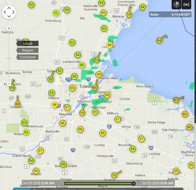
At 6:00 a.m., Toledo area temps were in the mid 50s, even within the city.
Toledo 7-day forecast
Last Update: Jul 3, 2015 3:04 am
Today: Mostly sunny, with a high near 76. Northeast wind 3 to 7 mph.
Tonight: Partly cloudy, with a low around 54. East wind around 6 mph becoming calm in the evening.
Independence Day: Sunny, with a high near 80. Calm wind becoming northwest around 5 mph in the afternoon.
Saturday Night: Mostly clear, with a low around 58. Southwest wind 3 to 5 mph.
Sunday: Sunny, with a high near 84. Light west wind.
Sunday Night: Mostly clear, with a low around 65.
Monday: Mostly sunny, with a high near 85.
Monday Night: Partly cloudy, with a low around 69.
Tuesday: A chance of showers and thunderstorms. Mostly cloudy, with a high near 80. Chance of precipitation is 50%.
Tuesday Night: A chance of showers and thunderstorms. Mostly cloudy, with a low around 66. Chance of precipitation is 50%.
Wednesday: A chance of showers and thunderstorms. Mostly cloudy, with a high near 77. Chance of precipitation is 40%.
Wednesday Night: A chance of showers and thunderstorms. Mostly cloudy, with a low around 64. Chance of precipitation is 30%.
Thursday: A chance of showers and thunderstorms. Mostly sunny, with a high near 78. Chance of precipitation is 30%.
area forecast discussion
national weather service cleveland oh
606 am edt fri jul 3 2015
synopsis... weak high pressure will remain over lake erie into
sunday then shift eat monday. a cold front will slowly move
southeast across the area late tuesday then stall and remain over
the ohio valley the rest of next week.
&&
near term /until 6 pm friday evening/... the upper trough axis will
be west of the cwa into this evening. this fact combined with how
weak the high is over the lakes will likely allow enough overrunning
to take place for some shra to spread back into at least the
southern part of the cwa by late today. will put chc pops back into
the forecast for later today and beef up the cloud cover more.
airmass is not overly unstable but still could be some isolated
thunder in the far south.
highs should run 75 to 80 this afternoon but some immediate
lakeshore areas could hold up only in the lower 70s.
&&
short term /6 pm friday evening through monday night/... per the
discussion above...tonight's forecast will start out with chances
for shra and maybe an isolated tsra in the far s and se. as the
upper trough axis works ese to be near the oh/pa line by 12z the
threat for rain will shift ese and should just be in the extreme
east by sat morning but the models differ some on how far to the
east the back edge will be by 12z so will leave a slight chc in the
east sat morning.
another upper s/w drops se across the east part of the snowbelt by
daybreak sun. moisture generally lacking but models do show some
light rain scattered just north of lake erie so will show a slight
increase in pops for this. the models differ on how much moisture
around 850 mb will be over the area sun for some widely sct
convection to develop. will increase the pops some but not enough
for precip to be mentioned yet.
upper ridging moves in sun night and should be over the area mon to
keep a cap on convective development. temps should finally warm a
little above normal for mon due to the upper ridge and winds from
the south. increasing south winds ahead of an approaching cold front
should moisten the lower levels enough for possible convection to
spread into the west toward daybreak tue so will place small chc
pops there late mon night.
&&
long term /tuesday through thursday/...the long term begins on
tuesday with the gfs and ecmwf showing a cold front poised just to
our northwest. moisture from the system will be moving into the
northwest during the morning. this deep moisture fills in during
the day and remains in place overnight as the slow moving front
moves slowly southeast through northern ohio. the front will remain
in the area thursday. will have chance pops through the long term
for showers and thunderstorms. best chances likely tuesday
afternoon through wednesday. temps largely seasonal.
&&
aviation /06z friday through tuesday/...
high pressure will continue across the great lakes...nrn ohio and
nwrn pa through friday however low pressure moving through the
ohio valley could bring a late day shower to southeastern
terminals from kmfd to kyng. also could see isolated mvfr
visibilities due to morning for inland northeast ohio. otherwise
vfr conditions expected.
outlook...non vfr conditions possible tuesday in showers and
thunderstorms.
&&
marine... high pressure will continue across the lower great lakes
through the day. a weak trof will cross lake erie saturday night but
high pressure will build back in for sunday and monday. a cold front
will move across the lake late tuesday. winds will be from the east
to northeast today into saturday before turning southwest. winds
will remain from the south to southwest saturday night through
tuesday. winds speeds will remain 15 knots or less and waves 2 feet
or less through the period.
&&
cle watches/warnings/advisories...
oh...none.
pa...none.
marine...none.
&&
$$
synopsis...adams
near term...adams
short term...adams
long term...tk
aviation...tk
marine...tk
From JR's : articles
899 words - 5330 chars
- 4 min read
created on
- #
source
- versions
Related articles
Severe weather threat for Sun, Nov 17, 2013 - Nov 18, 2013
Nov 17, 2013 Toledo area weather notes - Mar 03, 2014
Posts related to Nov 17, 2013 severe weather - Nov 21, 2013
Toledo area weather for early December 2013 - Dec 05, 2013
Mon, Dec 9, 2013 winter storm forecast for Sat, Dec 14 - Dec 14, 2013
more >>