Toledo weather sat sep 5 2015
Thunderstorms, including a couple severe ones, occurred yest in toledo area but it all missed west toledo. Some heavy rain occurred with some cells. Power out in Luckey from ~4:00 pm to after 9:00 pm.
hazardous weather outlook
national weather service cleveland oh
626 am edt sat sep 5 2015
ohz003-006>014-017>023-027>033-036>038-047-089-paz001>003-061030-
lucas-wood-ottawa-sandusky-erie oh-lorain-cuyahoga-lake-geauga-
ashtabula inland-hancock-seneca-huron-medina-summit-portage-trumbull-
wyandot-crawford-richland-ashland-wayne-stark-mahoning-marion-morrow-
holmes-knox-ashtabula lakeshore-northern erie-southern erie-
crawford pa-
626 am edt sat sep 5 2015
this hazardous weather outlook is for north central
ohio...northeast ohio...northwest ohio and northwest pennsylvania.
.day one...today and tonight.
scattered thunderstorms are possible today. locally heavy rainfall
will be the primary threat with thunderstorms with storm motion
of 10 mph or less. organized severe thunderstorms are not expected
but an isolated wind gust of 45 to 55 mph is possible.
.days two through seven...sunday through friday.
no hazardous weather is expected at this time.
.spotter information statement...
spotter activation is not expected at this time.
$$
special weather statement
special weather statement
national weather service cleveland oh
616 am edt sat sep 5 2015
ohz003-006>008-051115-
ottawa-lucas-wood-sandusky-
616 am edt sat sep 5 2015
...a line of thunderstorms producing very heavy rainfall will affect
western sandusky...ottawa...northeastern wood and northeastern lucas
counties...
at 608 am edt...a cluster of thunderstorms was located from east of
oregon to oak harbor and south to pemberville...and moving northwest
at 10 mph.
torrential rainfall is occurring with these storms...and may cause
ponding of water on roadways. do not drive your vehicle into
flooded roadways. motorists traveling on interstate 90 and routes 20
and 23 should exercise caution as they encounter very heavy rain.
frequent cloud to ground lightning is occurring with these storm.
lat...lon 4170 8344 4169 8343 4169 8336 4159 8309
4158 8305 4151 8306 4151 8308 4150 8307
4145 8311 4125 8335 4128 8360
time...mot...loc 1008z 175deg 16kt 4166 8327 4134 8351
$$
clark
At 7:10 am, a blob of mod-hvy rain still exists over eastern Lucas, northern Wood, and western Ottawa counties. Rain area is drifting very slowly to north but it appears that some individual cells are moving east.
Also a finger seems to be off shooting into Lucas county. Distant Thunder began being heard over west toledo at 6:55 to 7:00 am.
With the slow speed and mod-hvy rainfall, I'm guessing that flooding issues may temporarily occur if rain occurs over more urban areas.
Special Statement
Statement as of 6:16 AM EDT on September 05, 2015
... A line of thunderstorms producing very heavy rainfall will affect
western Sandusky... Ottawa... northeastern wood and northeastern Lucas
counties...
At 608 am EDT... a cluster of thunderstorms was located from east of
Oregon to Oak Harbor and south to Pemberville... and moving northwest
at 10 mph.
Torrential rainfall is occurring with these storms... and may cause
ponding of water on roadways. Do not drive your vehicle into
flooded roadways. Motorists traveling on Interstate 90 and routes 20
and 23 should exercise caution as they encounter very heavy rain.
Frequent cloud to ground lightning is occurring with these storm.
Lat... Lon 4170 8344 4169 8343 4169 8336 4159 8309
4158 8305 4151 8306 4151 8308 4150 8307
4145 8311 4125 8335 4128 8360
time... Mot... loc 1008z 175deg 16kt 4166 8327 4134 8351
Clark
616 am EDT Sat Sep 5 2015
... A line of thunderstorms producing very heavy rainfall will affect
western Sandusky... Ottawa... northeastern wood and northeastern Lucas
counties...
At 608 am EDT... a cluster of thunderstorms was located from east of
Oregon to Oak Harbor and south to Pemberville... and moving northwest
at 10 mph.
Torrential rainfall is occurring with these storms... and may cause
ponding of water on roadways. Do not drive your vehicle into
flooded roadways. Motorists traveling on Interstate 90 and routes 20
and 23 should exercise caution as they encounter very heavy rain.
Frequent cloud to ground lightning is occurring with these storm.
Lat... Lon 4170 8344 4169 8343 4169 8336 4159 8309
4158 8305 4151 8306 4151 8308 4150 8307
4145 8311 4125 8335 4128 8360
time... Mot... loc 1008z 175deg 16kt 4166 8327 4134 8351
Clark
link
fxus61 kcle 051048
afdcle
area forecast discussion
national weather service cleveland oh
648 am edt sat sep 5 2015
synopsis...
the upper level disturbance over michigan will weaken and lift
northeast today. a broad area of high pressure over new england will
move south along the east coast through the holiday weekend. a
weakening front will stall just north of the area on tuesday...then
push south on wednesday.
&&
near term /until 6 pm this evening/...
cluster of thunderstorms with efficient rainfall rates developed
over the last 2 hours producing heavy rainfall from vanlue to
fostoria to near woodville. storm motion is very slow with storms
building to north at 5-10 mph. radar estimates that some areas
have already had over 2 inches of rain and are monitoring for any
flooding issues. storms are approaching the toledo area and heavy
rain looks to impact at least the early portion of the morning
commute. it appears these thunderstorms have developed in an area
of moisture convergence ahead of the upper level circulation.
previous discussion...water vapor imagery still shows an upper
level circulation centered over southern lake michigan early this
morning. a few thunderstorms have been developing early this
morning across indiana and nw ohio ahead of the drier air wrapping
around the south side of the circulation. the ruc shows this spoke
of energy will tend to weaken over the next several hours. after
that models shows the upper level feature weakening and slowly
lifting ne across lower michigan through the afternoon. expect to
see the early morning convection in the west tend to weaken
through 13-14z then wait for instability to increase this
afternoon. coverage of showers and thunderstorms is expected to be
less than the past couple days given the weakening upper level
feature. sufficient instability is expected to develop again this
afternoon with pockets of cape in excess of 2000 j/kg. there will
be less of a trigger this afternoon with best chances for
initiation in nw ohio on the southern flank of the wave and ne
ohio along the lake breeze. although severe thunderstorms are
generally not expected...can not rule out a warning or two as
strong cells collapse. not enough shear for anything more
organized today.
with less cloud cover and precip than yesterday...temperatures will
rebound into the mid 80s in pa to near 90 in nw ohio.
&&
short term /6 pm this evening through tuesday night/...
thunderstorms will diminish this evening with heights building aloft
on sunday. the trend will continue for less thunderstorm activity
except for ne ohio/nw pa where thunderstorms will likely develop
again along the lake breeze. dewpoints start to mix out by monday
and expect dry conditions to finally prevail with the atmosphere
becoming increasingly capped.
the ridge aloft starts to flatten by tuesday as the upper trough
approaches the midwest. gfs is still more aggressive with shortwave
energy streaming northeast through the central great lakes on
tuesday afternoon ahead of the trough with thunderstorms developing.
the gfs is an outlier with this energy and outpaces the return of
the low-level moisture. expect convection to fill in tuesday night
as the slow moving frontal boundary sinks south. given the slower
timing...kept highs in the upper 80s to near 90 through tuesday.
&&
long term /wednesday through friday/...
both models signaling
change of the current weather pattern mid week. unfortunately the
ecmwf is coming into line with the latest gfs. although gfs a
little faster on the timing trend is still the same. models push
cold front across the forecast area on wednesday only to stall the
front across central ohio...with low pressure moving across the
lower lakes by the end of the work week. meanwhile at the upper
levels nice upper ridge will gradually be replaced by a digging
trough by this time next week.
&&
aviation /06z saturday through wednesday/...
little change in weather pattern. areas of mvfr br toward
daybreak with isolated convection this afternoon. do not think
there will be as much convection this afternoon as ydy.
outlook...areas of non vfr each morning in fog and haze.
&&
marine...
quiet weather will continue on the lake through the
weekend...although a chance of thunderstorm activity is possible
this afternoon. southwest flow will develop on the lake early in
the work week ahead of slow moving cold front. models continue to
hold off the next front until wednesday.
&&
cle watches/warnings/advisories...
oh...none.
pa...none.
marine...none.
&&
$$
synopsis...kec
near term...kec
short term...kec
long term...djb
aviation...djb
marine...djb
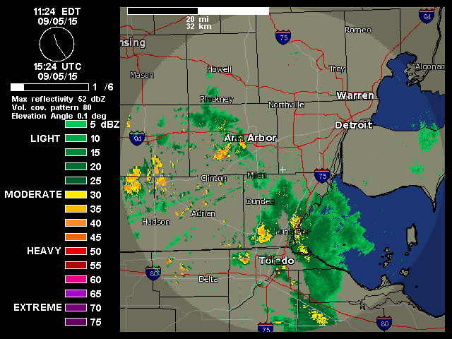
An odd cluster of thunderstorms formed after 4:00 am in the Toledo area, and as of 7:30 am, the mod-hvy rainfall still exists in the Toledo area, mainly over eastern Lucas, western Ottawa, and northern Wood counties. Some rain also existed in central Lucas County.
The rain area was drifting to the north at only 5 to 10 mph. Some areas have received a fair amount of rainfall, and localized flooding issues may occur.
At 8:00 am, still thundering over West Toledo, mainly distant-like grumbling. No rainfall here yet.
Radar shows a tiny cell of heavy rain approaching our neighborhood from the northwest.
Most of the mod-hvy rain exists over northern Wood and western Ottawa counties. This main area of rain has broken down some since 7:30 am.
A bunch of small cells formed rapidly over southeast Michigan and northern Lucas County between 7:30 and 8:00 am.
Rain began falling over our home at 8:07 am. Now moderate rain at 8:08 am. No wind.
Light rain over us at 8:15 a.m.
Rain nearly ended at 8:19 a.m. But scattered cells over southwest Monroe and southeast Lenawee counties may drift into Toledo later.
Only sprinkles at 8:21 a.m.
8:37 a.m.: very light rain was falling. rain over southwest Monroe County approached Sylvania. We may see this rain too. Rain over Lenawee and Monroe counties seems to be moving to the southeast.
8:54 a.m. : thunder getting closer. a moderate thundershower approaches from the northwest.
9:07 a.m. : light rain falling. maybe light-to-moderate. it appears that it will rain for a little while, like most of the next hour. forecast.io data says heavy rain for the hour for Sylvania and Central Toledo locations.
Sylvania:
Next Hour: Heavy rain for the hour.
9:05 am 100 chance of very heavy rain
9:06 am 100 chance of very heavy rain
9:07 am 100 chance of very heavy rain
9:08 am 100 chance of very heavy rain
9:09 am 100 chance of very heavy rain
9:10 am 100 chance of very heavy rain
9:11 am 100 chance of very heavy rain
9:12 am 100 chance of very heavy rain
9:13 am 100 chance of very heavy rain
9:14 am 100 chance of very heavy rain
9:15 am 100 chance of very heavy rain
9:16 am 100 chance of very heavy rain
9:17 am 100 chance of very heavy rain
9:18 am 100 chance of very heavy rain
9:19 am 100 chance of heavy to very heavy rain
9:20 am 100 chance of heavy to very heavy rain
9:21 am 100 chance of heavy to very heavy rain
9:22 am 100 chance of heavy to very heavy rain
9:23 am 100 chance of heavy to very heavy rain
9:24 am 100 chance of heavy to very heavy rain
9:25 am 100 chance of heavy to very heavy rain
9:26 am 100 chance of heavy to very heavy rain
9:27 am 100 chance of heavy to very heavy rain
9:28 am 100 chance of heavy to very heavy rain
9:29 am 100 chance of heavy rain
9:30 am 100 chance of heavy rain
9:31 am 99 chance of heavy rain
9:32 am 99 chance of heavy rain
9:33 am 99 chance of heavy rain
9:34 am 99 chance of heavy rain
9:35 am 99 chance of heavy rain
9:36 am 99 chance of heavy rain
9:37 am 99 chance of heavy rain
9:38 am 99 chance of heavy rain
9:39 am 99 chance of heavy rain
9:40 am 98 chance of moderate to heavy rain
9:41 am 98 chance of moderate to heavy rain
9:42 am 98 chance of moderate to heavy rain
9:43 am 98 chance of moderate to heavy rain
9:44 am 98 chance of moderate to heavy rain
9:45 am 97 chance of moderate to heavy rain
9:46 am 97 chance of moderate to heavy rain
9:47 am 97 chance of moderate to heavy rain
9:48 am 96 chance of moderate to heavy rain
9:49 am 96 chance of moderate to heavy rain
9:50 am 96 chance of moderate to heavy rain
9:51 am 95 chance of moderate rain
9:52 am 94 chance of moderate rain
9:53 am 93 chance of moderate rain
9:54 am 92 chance of moderate rain
9:55 am 91 chance of moderate rain
9:56 am 91 chance of moderate rain
9:57 am 90 chance of moderate rain
9:58 am 89 chance of moderate rain
9:59 am 88 chance of moderate rain
10:00 am 87 chance of moderate rain
10:01 am 86 chance of moderate rain
10:02 am 84 chance of moderate rain
10:03 am 83 chance of moderate rain
10:04 am 82 chance of moderate rain
10:05 am 80 % chance of moderate rain
Central Toledo:
Next Hour: Heavy rain for the hour.
9:05 am 100 chance of very heavy rain
9:06 am 100 chance of very heavy rain
9:07 am 100 chance of very heavy rain
9:08 am 100 chance of very heavy rain
9:09 am 100 chance of very heavy rain
9:10 am 100 chance of very heavy rain
9:11 am 100 chance of very heavy rain
9:12 am 100 chance of very heavy rain
9:13 am 100 chance of very heavy rain
9:14 am 100 chance of very heavy rain
9:15 am 100 chance of very heavy rain
9:16 am 100 chance of very heavy rain
9:17 am 100 chance of very heavy rain
9:18 am 100 chance of very heavy rain
9:19 am 100 chance of very heavy rain
9:20 am 100 chance of very heavy rain
9:21 am 100 chance of very heavy rain
9:22 am 100 chance of very heavy rain
9:23 am 100 chance of very heavy rain
9:24 am 100 chance of heavy to very heavy rain
9:25 am 100 chance of heavy to very heavy rain
9:26 am 100 chance of heavy to very heavy rain
9:27 am 100 chance of heavy to very heavy rain
9:28 am 100 chance of heavy to very heavy rain
9:29 am 100 chance of heavy to very heavy rain
9:30 am 100 chance of heavy to very heavy rain
9:31 am 100 chance of heavy to very heavy rain
9:32 am 100 chance of heavy to very heavy rain
9:33 am 100 chance of heavy to very heavy rain
9:34 am 100 chance of heavy to very heavy rain
9:35 am 100 chance of heavy to very heavy rain
9:36 am 100 chance of heavy rain
9:37 am 100 chance of heavy rain
9:38 am 100 chance of heavy rain
9:39 am 100 chance of heavy rain
9:40 am 100 chance of heavy rain
9:41 am 100 chance of heavy rain
9:42 am 100 chance of heavy rain
9:43 am 100 chance of heavy rain
9:44 am 100 chance of heavy rain
9:45 am 100 chance of heavy rain
9:46 am 100 chance of heavy rain
9:47 am 99 chance of heavy rain
9:48 am 99 chance of heavy rain
9:49 am 99 chance of heavy rain
9:50 am 99 chance of heavy rain
9:51 am 99 chance of heavy rain
9:52 am 99 chance of heavy rain
9:53 am 99 chance of heavy rain
9:54 am 99 chance of heavy rain
9:55 am 99 chance of heavy rain
9:56 am 99 chance of heavy rain
9:57 am 98 chance of heavy rain
9:58 am 98 chance of heavy rain
9:59 am 98 chance of moderate to heavy rain
10:00 am 98 chance of moderate to heavy rain
10:01 am 98 chance of moderate to heavy rain
10:02 am 97 chance of moderate to heavy rain
10:03 am 97 chance of moderate to heavy rain
10:04 am 97 chance of moderate to heavy rain
10:05 am 97 % chance of moderate to heavy rain
9:08 a.m. : raining a little harder. we'll probably have a steady period of at least light to moderate rain with occasional increases to moderate to heavy, according to radar. forecast.io data indicates a little heavier rainfall.
9:13 a.m. - moderate rainfall with occasional thunder.
9:45 a.m. - light rain falling. still some occasional thunder. this is a little break for us. the small, trailing edge area of moderate rain will move in soon.
9:58 a.m. - radar showed rain area quickly breaking down. we may only have light rain for a little while longer.
10:06 a.m. - light to moderate rain falling. a small spot of heavier rain moving over us now.
10:30 a.m. - rain has nearly ended. low cloud cover. low light morning. need lights on.
10:33 a.m. - nearby thunder. some scattered tiny cells may move through our area still this morning.
At 10:37 a.m., I emptied my rain gauge, and it measure 0.65 inches of #rainfall since the rain began at 8:07 a.m.
At 10:39 a.m., moderate rainfall is occurring, just after I emptied the rain gauge.
My 10:43 TT comment:
We have received at least 1.5" so far in West Toledo."
Interesting. As of 10:37 a.m., only 0.65 inches of rain has fallen on "my" part of West Toledo, since the rain began at 8:07 a.m., although it just now started pouring again.
The rain over West Toledo has come from small cells that moved in from southeast Lenawee and southwest Monroe counties. A bit of a "training" situation has setup, so it's possible that some locations got hit harder than others over a small area.
10:47 a.m. : loudest, closest lightning/thunder incident this morning.
11:35 a.m. : not raining. cloudy but light increasing. scattered rain is nearby though.
I'll add to the image-heavy thread.
Radar estimates show that at least 2 to 4 inches of rain have fallen this morning over a north-south area of eastern Hancock, eastern Wood, eastern Lucas, western Ottawa, western Sandusky, and western Seneca counties.
Screen capture. Enlarge image
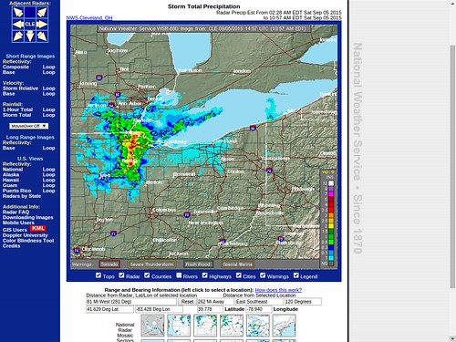
That's from the rain area that formed after 4:00 or 5:00 a.m. and then drifted very slowly to the north if it moved at all.
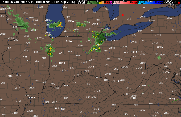
Here's a radar loop from 6:00 a.m. to 8:00 a.m. EDT, showing the nearly stationary rain blob that was located mostly east and south of Toledo. And you can see the numerous small cells that formed quickly in southeast Michigan between 7:30 a.m. and 8:00 a.m.
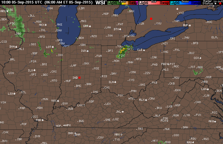
That slow-moving rain blob did not impact the western half of Lucas County. We received our rain from the small cells moving southeast from Michigan.
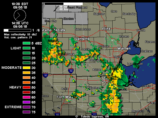
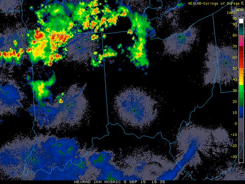
Here's a radar loop from 9:00 a.m. to 11:00 a.m. EDT. The main blob has moved little.
Radar loop ending at 11:05 a.m. that also shows how the "blob" is remaining mostly stationary and just breaking down over time. Obviously, more Michigan rain may move into our area.
Radar loop ending at 11:32 a.m. shows scattered rain debris in Lucas County.
11:35 a.m. snapshot.
A bit of a wackadoo rain morning over the Great Black Swamp.
And we have a chance for thunderstorms this afternoon and evening, depending upon how much sunshine and heating we receive today.
Around 11:30 a.m., Toledo area temps were only in the upper 60s.
Our forecast as of 10:00 a.m.:
Today: Isolated showers and thunderstorms before 2pm, then isolated showers and thunderstorms after 3pm. Partly sunny, with a high near 85. Southwest wind 5 to 8 mph. Chance of precipitation is 20%.
At 12:00 p.m., I emptied the rain gauge again. It measured 0.37 inches of rain that fell since I last emptied it at 10:37 a.m.
Total rainfall for the day, since it began at 8:07 a.m.: 1.02 inches.
Rain in southern Michigan may reach us later.
Toledo 7-day forecast
Last Update: Sep 5, 2015 4:20 pm
This Afternoon: Scattered showers and thunderstorms. Mostly cloudy, with a high near 85. Southwest wind around 7 mph. Chance of precipitation is 30%. New rainfall amounts of less than a tenth of an inch, except higher amounts possible in thunderstorms.
Tonight: Scattered showers and thunderstorms, mainly before 11pm. Mostly cloudy, with a low around 66. Light south wind. Chance of precipitation is 40%. New precipitation amounts of less than a tenth of an inch, except higher amounts possible in thunderstorms.
Sunday: Mostly sunny, with a high near 90. South wind 3 to 6 mph.
Sunday Night: Partly cloudy, with a low around 65. South wind 3 to 6 mph.
Labor Day: Mostly sunny, with a high near 90. Southwest wind 6 to 10 mph.
Monday Night: A chance of showers and thunderstorms after 1am. Mostly cloudy, with a low around 69. Chance of precipitation is 30%. New rainfall amounts of less than a tenth of an inch, except higher amounts possible in thunderstorms.
Tuesday: A chance of showers and thunderstorms before 7am, then a chance of showers and thunderstorms after 1pm. Partly sunny, with a high near 88. Chance of precipitation is 30%.
Tuesday Night: A chance of showers and thunderstorms. Cloudy, with a low around 68. Chance of precipitation is 50%.
Wednesday: Showers and thunderstorms likely. Mostly cloudy, with a high near 80. Chance of precipitation is 60%.
Wednesday Night: Showers and thunderstorms likely, mainly before 9pm. Mostly cloudy, with a low around 62. Chance of precipitation is 60%.
Thursday: Mostly cloudy, with a high near 76.
Thursday Night: Mostly cloudy, with a low around 58.
Friday: Mostly sunny, with a high near 74.
Friday Night: Partly cloudy, with a low around 53.
Saturday: Mostly sunny, with a high near 71.
From JR's : articles
3639 words - 21417 chars
- 20 min read
created on
updated on
- #
source
- versions
Related articles
Toledo weather sat jun 27 2015 - Jun 27, 2015
June 2015 Rainfall - Jul 02, 2015
Tt comment oct 28, 2015 - b - Oct 28, 2015
Severe weather threat for Sun, Nov 17, 2013 - Nov 18, 2013
Nov 17, 2013 Toledo area weather notes - Mar 03, 2014
more >>