You're viewing old version number 8. - Current version
Toledo weather sun jun 21 2015
the morning HWO did not mention a risk for storms on Monday even though the SPC's Day 2 convective outlook showed the Toleod area barely contained within the Slight Risk for severe thunderstorms.
The Day 2 convective outlook is the same. I think someone on a later shift at the Cle NWS realized the earlier miss. Maybe a person remembered that Lucas County is part of the Cle NWS's CWA.
hazardous weather outlook
national weather service cleveland oh
1124 am edt sun jun 21 2015
for lake erie...north central
ohio...northeast ohio...northwest ohio and northwest pennsylvania.
.day one...this afternoon and tonight.
hazardous weather is not expected at this time.
.days two through seven...monday through saturday.
there is a chance for severe storms later monday and monday
night.
severe thunderstorms are expected to develop across the central
great lakes on monday. these storms will likely move toward lake
erie. it is uncertain at this time how long and how far east the
severe storms will persist. the best chance for severe storms
appears to be across northwest ohio. wind damage and large hail
will be the greatest threat although a tornado is possible.
.spotter information statement...
spotter activation may be necessary monday or monday night.
spc ac 210602
day 2 convective outlook
nws storm prediction center norman ok
0102 am cdt sun jun 21 2015
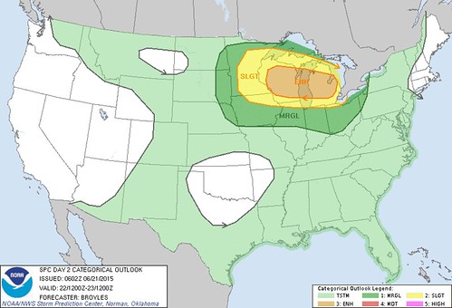
valid 221200z - 231200z
...there is an enh risk of svr tstms across parts of far se
mn...wi...lake michigan and lower mi...
...there is a slgt risk of svr tstms across parts of the upper ms
valley and great lakes region...
...there is a mrgl risk of svr tstms across parts of the nrn
plains...mid to upper ms valley...great lakes region and nrn oh
valley...
...summary...
severe thunderstorms will be possible across the upper mississippi
valley and great lakes region on monday where a few
tornadoes...damaging wind gusts and isolated large hail may occur. a
threat for strong tornadoes and wind gusts of greater than 65 knots
will be possible. marginally severe thunderstorms may occur across
the mid missouri valley...mid to upper mississippi valley and
northern ohio valley.
...upper ms valley/great lakes region...
a vigorous upper-level trough will move ewd across the nrn plains
into the upper ms valley on monday as an impressive 60 to 80 kt
mid-level jet overspreads the upper ms valley and great lakes
region. at the sfc...a low is forecast to move quickly newd from the
mid mo valley into the great lakes region as a cold front advances
sewd into the upper ms valley. ahead of the front...a very moist
airmass should be in place with sfc dewpoints in the lower 70s f
which should enable moderate to strong instability to develop across
much of the mid to upper ms valley by afternoon.
in addition to the strong instability...model forecasts show
impressive shear profiles and an upper-level system that appears
quite organized with a well-defined low to mid-level jet couplet.
this could result in a significant event occurring across parts of
the upper ms valley and great lakes region on monday. considering
the nam...gfs and ecmwf models...the nam and gfs appear to the be
most aggressive solutions while the ecmwf is slightly more
conservative concerning the amount of instability...shear and
organization with the upper-level system. many problems exist for
determining the most likely corridor for severe including 1) how
morning convection will impact the setup in the afternoon and 2) how
far north will the capping inversion impede convective development.
the current thinking is that a morning mcs with wind damage
potential will track esewd from ern mn and ern ia across srn
wi...nrn il and into ind around midday. further west behind the
morning mcs...an axis of strong instability will develop from nrn mo
nwd into ern ia with new convection initiating on the nrn end of the
strong instability in far se mn and nwrn wi during the afternoon.
this convection should move ewd and gradually grow upscale. nam
forecast soundings at 21z on monday for madison wi show impressive
thermodynamics and shear profiles with mlcape above 4000 j/kg and
0-6 km shear from 60 to 70 kt. this would be very favorable for
severe storms including supercells. it seems possible that a cluster
of supercells could organize during the mid to late
afternoon...moving ewd across cntrl and ern wi and crossing lake mi
into lower mi by early evening. strong low-level shear could support
a threat for strong tornadoes and a long-track tornado can not be
ruled out. the other possibility is for a severe wind producing
linear mcs that moves quickly esewd across wi during the late
afternoon reaching lower mi by early evening. due to the possibility
of a high-end event for either tornadoes or wind damage...the
enhanced area will be expanded to include most of wi and lower mi
with the significant hatched area also including sern mn.
..broyles.. 06/21/2015
click to get wuus02 ptsdy2 product
note: the next day 2 outlook is scheduled by 1730z

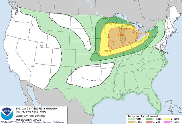
spc ac 211732
day 2 convective outlook
nws storm prediction center norman ok
1232 pm cdt sun jun 21 2015
valid 221200z - 231200z
...there is an enh risk of svr tstms great lakes and upper ms
valley...
...there is a slgt risk of svr tstms from the upper midwest to lower
great lakes...
...there is a mrgl risk of svr tstms across parts of the n-cntrl/ne
states...
...summary...
scattered severe storms are likely across parts of the upper
mississippi valley and great lakes regions...some of which should be
intense...mainly from midday through the evening on monday.
...upper ms valley/great lakes...
strongly considered an upgrade to moderate risk with potential for
clusters of intense severe storms with all significant severe
hazards possible. but will defer given enough uncertainty with
regard to evolution of late d1 convection with its subsequent effect
on the degree of downstream diurnal destabilization...along with
timing of the pair of mid-level shortwave impulses with respect to
peak heating.
guidance is consistent in depicting strengthening
low/mid-tropospheric flow in response to a convectively-generated
mcv from late d1/early d2 and approach of an upstream shortwave
trough currently over the srn canadian rockies. these features would
enhance low-level waa of the richly buoyant air mass currently
present over the lower mo valley. available cams vary markedly with
the daytime evolution of an mcs expected to be ongoing across parts
of srn mn/nrn ia. it seems plausible that this activity should
persist through the day with an organized severe risk on the edge of
a robust plains eml. this type of scenario may result in lead
convection outpacing the more favorable thermodynamic environment
characterized by rather steep mid-level lapse rates and very large
buoyancy.
at least scattered upstream tstm development should occur by late
afternoon along the cold front from cntrl/ern wi sw to the ia/il
border area as convergence along the front and diabatic heating
overcome inhibition due to the initially stout eml. supercells are
expected in initial stages of development...with some of this
convection growing upscale during the evening. with low-level flow
becoming increasingly veered in the wake of the lead mid-level
impulse...main hazards with sw extent should be very large hail
transitioning to predominately severe wind. where 850 mb winds can
remain quite strong with enlarged low-level hodographs /most likely
in ern wi to lower mi/...a risk for strong tornadoes and/or
significant severe wind gusts may develop.
..grams.. 06/21/2015
click to get wuus02 ptsdy2 product
note: the next day 2 outlook is scheduled by 0600z
At early Sun afternoon, Jun 21, the SPC increased the sizes for Slight Risk and Enhanced Risk, regarding chances for severe weather for Mon, Jun 22.
The biggest chances for severe weather remain north and west of Toledo.
Forecast issued at 1:32 p.m. EDT on Sun, Jun 21 for Mon, Jun 22
Probability of severe weather within 25 miles of a point on Mon, Jun 22.
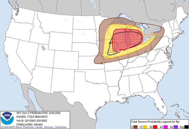
Excerpts from the 1:32 p.m., Sun, Jun 21 Day 2 Convective Outlook for Mon, Jun 22:
strongly considered an upgrade to moderate risk with potential for clusters of intense severe storms with all significant severe hazards possible. but will defer given enough uncertainty ...... most likely in ern wi to lower mi/ ...a risk for strong tornadoes and/or significant severe wind gusts may develop.
This afternoon's version of the Day 2 Convective Outlook seemed a little less ominous than the Day 2 forecast that was issued very early this morning.
... this would be very favorable for severe storms including supercells. it seems possible that a cluster of supercells could organize during the mid to late afternoon [Monday] ...moving ewd across cntrl and ern wi and crossing lake mi into lower mi by early evening.strong low-level shear could support a threat for strong tornadoes and a long-track tornado can not be ruled out.
the other possibility is for a severe wind producing linear mcs that moves quickly esewd across wi during the late afternoon reaching lower mi by early evening.
It does appear that the weather could be bumpy on Monday over the western half of Michigan's lower peninsula.
It's uncertain if a thunderstorm cluster will remain strong enough to be severe by the time it reaches the Toledo area on Monday evening.
Excerpts from the 11:24 a.m., Sun, Jun 21 Hazardous Weather Outlook, issued by the Cle NWS:
severe thunderstorms are expected to develop across the central great lakes on monday. these storms will likely move toward lake erie. it is uncertain at this time how long and how far east the severe storms will persist.the best chance for severe storms appears to be across northwest ohio. wind damage and large hail will be the greatest threat although a tornado is possible.
[SKYWARN] spotter activation may be necessary monday or monday night.
From JR's : articles
1631 words - 10012 chars
- 9 min read
created on
updated on
- #
source
- versions
Related articles
Severe weather threat for Sun, Nov 17, 2013 - Nov 18, 2013
Nov 17, 2013 Toledo area weather notes - Mar 03, 2014
Posts related to Nov 17, 2013 severe weather - Nov 21, 2013
Toledo area weather for early December 2013 - Dec 05, 2013
Mon, Dec 9, 2013 winter storm forecast for Sat, Dec 14 - Dec 14, 2013
more >>